Chapter 5

Changes in Snow, Ice, and Permafrost Across Canada

This chapter presents evidence that snow, ice, and permafrost are changing across Canada because of increasing temperatures and changes in precipitation.

Recommended citation

Derksen, C., Burgess, D., Duguay, C., Howell, S., Mudryk, L., Smith, S., Thackeray, C. and Kirchmeier-Young, M. (2019): Changes in snow, ice, and permafrost across Canada; Chapter 5 in Canada’s Changing Climate Report, (ed.) E. Bush and D.S. Lemmen; Government of Canada, Ottawa, Ontario, p. 194-260.

Authors

  • Chris Derksen (Environment and Climate Change Canada)
  • David Burgess (Natural Resources Canada)
  • Claude Duguay (University of Waterloo)
  • Stephen Howell (Environment and Climate Change Canada)
  • Lawrence Mudryk (Environment and Climate Change Canada)
  • Sharon Smith (Natural Resources Canada)
  • Chad Thackeray (University of California at Los Angeles)
  • Megan Kirchmeier-Young (Environment and Climate Change Canada)
Figure-5.1
View details
Figure-5.2
View details
Figure-5.3
View details
Figure-5.4
View details
Figure-5.5
View details
Figure-5.6
View details
Figure-5.7
View details
Figure-5.8
View details
Figure-5.9
View details
Figure-5.10
View details
Figure-5.11
View details
Figure-5.12
View details
Figure-5.13
View details
Figure-5.14
View details
Figure-5.15
View details
Figure-5.16
View details
Interactive Figure 5.17
View details
Interactive Figure 5.18
View details

Chapter Key Messages

SNOW COVER

The portion of the year with snow cover decreased across most of Canada (very high confidence1) as did the seasonal snow accumulation (medium confidence). Snow cover fraction decreased between 5% and 10% per decade since 1981 due to later snow onset and earlier spring melt. Seasonal snow accumulation decreased by 5% to 10% per decade since 1981 with the exception of southern Saskatchewan, and parts of Alberta and British Columbia (increases of 2% to 5% per decade).

It is very likely that snow cover duration will decline to mid-century across Canada due to increases in surface air temperature under all emissions scenarios. Scenario-based differences in projected spring snow cover emerge by the end of the century, with stabilized snow loss for a medium emission scenario but continued snow loss under a high emission scenario (high confidence). A reduction of 5% to 10% per decade in seasonal snow accumulation is projected through to mid-century for much of southern Canada; only small changes in snow accumulation are projected for northern regions of Canada (medium confidence).


SEA ICE

Perennial sea ice in the Canadian Arctic is being replaced by thinner seasonal sea ice (very high confidence). Summer sea ice area (particularly multi-year ice area) declined across the Canadian Arctic at a rate of 5% per decade to 20% per decade since 1968 (depending on region); winter sea ice area decreased in eastern Canada by 8% per decade.

It is very likely that increased temperatures under all emissions scenarios will result in continued reduction in sea ice area across the Canadian Arctic in summer and the east coast in winter. Most Canadian Arctic marine regions will be sea ice-free for part of the summer by 2050 (medium confidence), although the region to the north of the Canadian Arctic Archipelago and Greenland will be the last area in the Arctic with multi-year ice present during the summer (very high confidence). Multi-year ice will, therefore, still drift into the Northwest Passage (and present a navigation hazard for shipping) even when the Arctic Ocean is sea ice-free during the summer.

GLACIERS AND ICE CAPS

Canada’s Arctic and alpine glaciers have thinned over the past five decades due to increasing surface temperatures; recent mass loss rates are unprecedented over several millennia (very high confidence). Mass loss from glaciers and ice caps in the Canadian Arctic represent the third largest cryosphere contributor to global sea level rise (after the Greenland and Antarctic ice sheets) (very high confidence).

Under a medium emission scenario, it is projected that glaciers across the Western Cordillera will lose 74% to 96% of their volume by late century (high confidence). An associated decline in glacial meltwater supply to rivers and streams (with impacts on freshwater availability) will emerge by mid-century (medium confidence). Most small ice caps and ice shelves in the Canadian Arctic will disappear by 2100 (very high confidence).

LAKE AND RIVER ICE

The duration of seasonal lake ice cover has declined across Canada over the past five decades due to later ice formation in fall and earlier spring breakup (high confidence). Seasonal maximum lake ice cover for the Great Lakes is highly variable since 1971 (very high confidence), with no significant trend.

Spring lake ice breakup will be 10 to 25 days earlier by mid-century, and fall freeze-up 5 to 15 days later, depending on the emissions scenario and lake-specific characteristics such as depth (medium confidence).

PERMAFROST

Permafrost temperature has increased over the past 3–4 decades (very high confidence). Regional observations identify warming rates of about 0.1°C per decade in the central Mackenzie Valley and 0.3°C to 0.5°C per decade in the high Arctic. Active layer thickness has increased by approximately 10% since 2000 in the Mackenzie Valley. Widespread formation of thermokarst landforms have been observed across northern Canada.

Increases in mean air temperature over land underlain with permafrost are projected under all emissions scenarios, resulting in continued permafrost warming and thawing over large areas by mid-century (high confidence) with impacts on northern infrastructure and the carbon cycle.
 

Summary

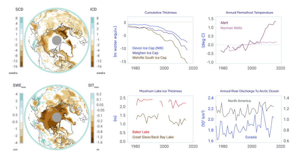
Over the past three decades, the proportion of Canadian land and marine areas covered by snow and ice have decreased, and permafrost temperatures have risen (see Figure 5.1). These changes to the Canadian cryosphere are consistent to those observed in other northern regions (Alaska, northern Europe, and Russia).

Figure-5.1

Indicators of changes in the cryosphere as a result of warming

: Two maps show differences between the periods 2006–2015 and 1981–1990 for the Northern Hemisphere north of 50° north latitude. The first map shows differences in snow and ice cover duration; the second map shows differences in seasonal maximum snow water equivalent and sea ice thickness. The strongest decreases in snow cover duration and maximum snow water equivalent are for eastern Canada, Alaska, northern Europe, and western Siberia. Sea ice cover duration decreased over all Arctic sea ice areas except the interior of the Arctic Ocean. Sea ice thickness decreased over the entire Arctic and all peripheral seas. Four line graphs show time series since 1980 of (1) cumulative ice cap volume change for three locations in the Canadian Arctic Archipelago; (2) permafrost temperature at Norman Wells and Alert; (3) lake ice thickness from measurements on Great Slave Lake and Baker Lake; (4) continentally averaged river discharge to the Arctic Ocean from North America and Eurasia. The line graphs show trends of ice cap volume loss, warming ground temperature, decreasing lake ice thickness, and increasing river discharge.
Figure-5.1

Left: Difference in snow cover duration (SCD) and sea ice cover duration (ICD; upper), and in seasonal maximum snow water equivalent (SWEmax) and sea ice thickness (SITmax; lower) between the periods 2006–2015 and 1981–1990. Right: Time series of cumulative specific volume change (the running total of ice cap surface mass balance divided by ice cap area) for three ice caps in the Canadian Arctic; annual mean ground temperature departure in the sub-Arctic Mackenzie Valley (Norman Wells) and high Arctic (Alert) relative to the 1988–2007 mean; annual maximum lake ice thickness (Great Slave Lake, Northwest Territories and Baker Lake, Nunavut); and annual river discharge summed for rivers draining into the Arctic Ocean from North America and Eurasia.

Source

SCD and SWE from a blend of five snow products; ICD from satellite passive microwave data; and SIT from the PIOMAS Arctic Sea Ice Volume Reanalysis. Ice cap volume data from David Burgess, Natural Resources Canada; ground temperature data from Sharon Smith, Natural Resources Canada; lake ice thickness data from Claude Duguay, University of Waterloo; Arctic river discharge data from Stephen Dery, University of Northern British Columbia.

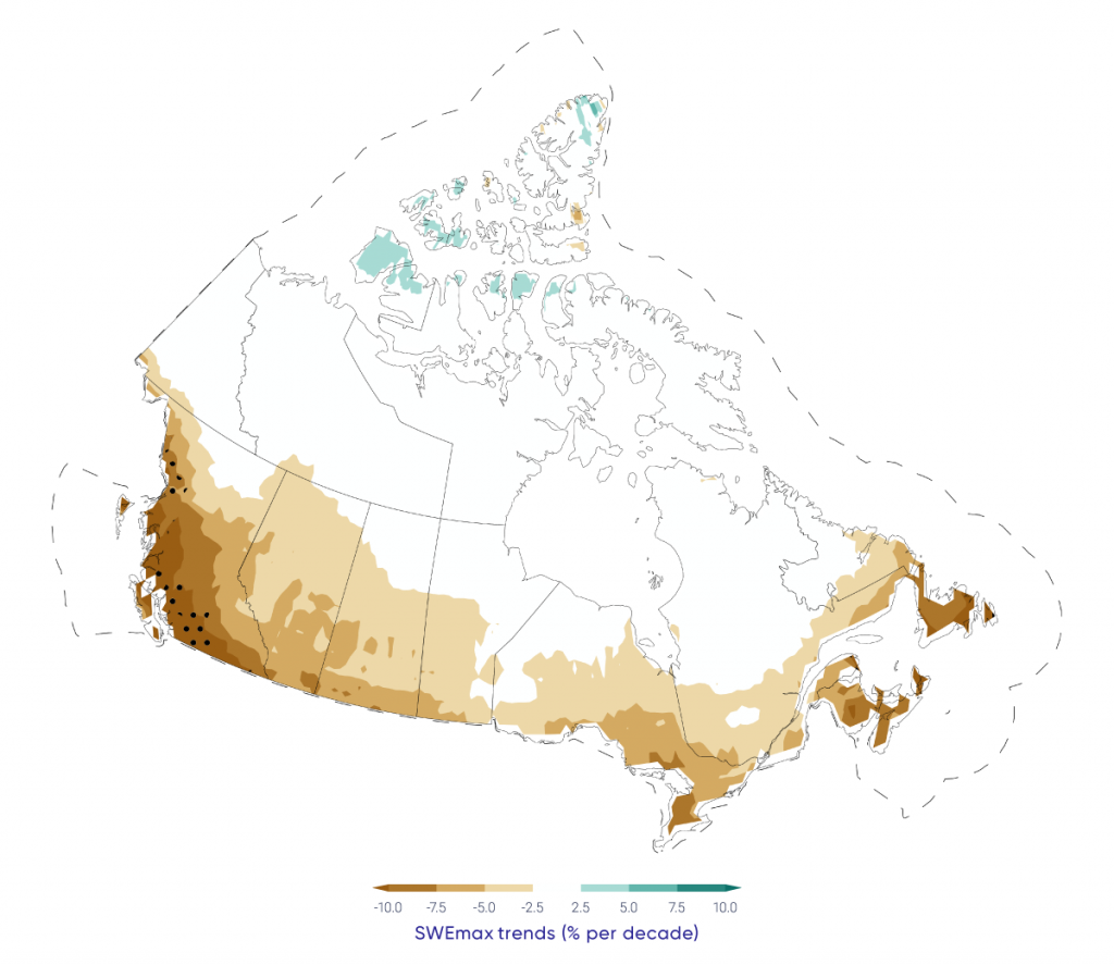
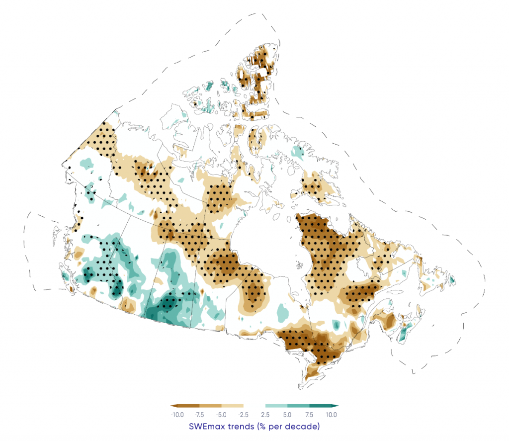
Snow cover fraction (SCF) decreased across most of Canada during the 1981–2015 period due to delayed snow cover onset in fall and earlier snow melt in spring. Regional and seasonal variability in the SCF trends reflects internal climate variability in surface temperature trends. Over the same time period, seasonal maximum snow water equivalent (SWEmax), which is indicative of seasonally accumulated snow available for spring melt, decreased across the Maritimes, southern Ontario, and nearly all of Canadian land areas north of 55° north latitude, while it increased across southern Saskatchewan and parts of Alberta and British Columbia.

Significant reductions in sea ice area over the period 1968–2016 were evident in the summer and fall across the Canadian Arctic (5% to 20% per decade, depending on region), and in winter and spring in eastern Canadian waters (5% to 10% per decade). Perennial sea ice in the Canadian Arctic is being replaced by thinner seasonal sea ice: multi-year ice losses are greatest in the Beaufort Sea and the Canadian Arctic Archipelago (CAA), approaching 10% per decade. Sixty-year records of landfast sea ice thickness show evidence of thinning ice in the CAA.

Glaciers in Canada have receded over the past century, with a rapid acceleration in area and mass losses over the past decade, due primarily to increasing air temperature. Recent mass loss rates are unprecedented over several millennia. Lake ice cover is changing across Canada, driven primarily by earlier spring breakup. Seasonal ice cover duration declined for approximately 80% of Arctic lakes between 2002 and 2015. Permafrost in the central and southern Mackenzie Valley has warmed at a rate of approximately 0.2°C per decade since the mid-1980s. While modest, these increases are important because permafrost temperatures in these regions are currently close to zero, so the ground is vulnerable to thawing. Permafrost temperatures in the high Arctic have increased at higher rates than in the sub-Arctic, ranging between 0.7°C and 1°C per decade.

These changes to the cryosphere during recent decades are in large part a response to increasing surface temperatures. Regional and seasonal variability are due to natural climate variability in surface temperature trends, changes in the amount and the phase (rain or snow) of precipitation, and to remote influences within the global climate system (such as variations in ocean circulation and sea surface temperatures). Changes to individual components of the cryosphere are interconnected. For example, snow is an effective insulator, so changes in the timing of snow cover onset and the seasonal accumulation of snow strongly influence underlying ground temperature and the thickness of lake and sea ice.

Further changes to the cryosphere over the coming decades are virtually certain, as temperatures are projected to increase under all future emission scenarios. There is robust evidence that snow cover extent and accumulation, sea ice extent and overall thickness, and the mass of land ice will continue to decrease across Canada throughout the 21st century. Most Canadian Arctic marine regions could be sea ice–free for at least one month in the summer by 2050, but sea ice will continue to be found along the northern coast of the CAA. Reductions in glacier mass in western Canada will impact the magnitude and seasonality of streamflow, affecting the availability of freshwater for human use. Warming will lead to a loss of permafrost and alteration of the landscape as thawing occurs. These changes to the cryosphere will not be spatially uniform due to regional effects of natural climate variability at decadal to multi-decadal time scales.

5.1

Introduction

The term “cryosphere” refers to places on the Earth where water is frozen, and includes snow, sea ice, land ice (glaciers and ice caps), freshwater ice (lake and river ice), permafrost, and seasonally frozen ground. Although the term may not be broadly familiar to Canadians, the cryosphere is a defining component of Canada’s landscape for at least part of each year, and for the entire year at higher latitudes and elevations.

The cryosphere plays a key role in the climate system by influencing surface reflectivity (albedo — snow and ice are highly reflective of incoming solar energy; see Chapter 2, Box 2.3), heat transfer (snow is a highly effective insulator of the underlying soil or ice), and hydrological processes (water storage and runoff). It also has important ecosystem linkages, as many organisms have adapted to living in or on snow and ice. These range from distinctive microbial communities, to seals and polar bears, which rely on sea ice for breeding, feeding, and mobility. Ice cover influences the algae growing season, water temperature, and oxygen levels, as well as allowing wildlife to reach shorelines and cross water bodies. The state of the cryosphere also influences the Canadian economy by supplying freshwater from snow and glaciers for human use during melt periods, impacting shipping and offshore operations, facilitating northern transportation and resource extraction through ice roads, and supporting winter recreation. It also contributes to a wide range of hazards such as spring flooding, avalanches, as well as landscape instability as permafrost thaws. The cryosphere is also critically important in the traditional ways of life of many Indigenous communities, particularly in the North. As well as influencing the abundance and location of land, freshwater, and marine resources on which these communities depend, snow, ice, and permafrost also affect access to these resources.

This chapter provides an assessment of observed and projected changes in the Canadian cryosphere. This updates a review conducted as part of the 2007/2008 International Polar Year (Derksen et al., 201238) and a previous overview of Canada’s changing climate (Bush et al., 201429), as well as complementing recent assessments of the global (Vaughan et al., 2013187) and Arctic (AMAP, 2017a5) cryosphere. When appropriate, the longest available datasets of continuous surface measurements from observation sites are provided (for example, glacier mass balance, permafrost temperature). Otherwise, validated datasets from remote sensing and land surface models are utilized to provide information for large areas (for example, sea ice concentration, snow cover fraction, lake ice cover). The historical periods vary between components of the cryosphere, depending on the available data, but extend from at least 1981 to present. Projected changes to the cryosphere are based on state-of-the-art climate model simulations from the fifth phase of the Coupled Model Intercomparison Project (CMIP5) (https://esgf-node.llnl.gov/projects/cmip5/) (see Chapter 3, Box 3.1). In some cases, these models simulate variables that can be directly compared with observations — for example, snow cover fraction. In other cases, analysis of model projections is more complicated, either because the models do not directly simulate the variable of interest (e.g., permafrost area needs to be inferred from soil temperature) or the spatial resolution of global models is too coarse to provide information on individual features of interest (i.e., specific lakes or glaciers) (see Chapter 3, Figure 3.2 for an explanation of models).

Changes in temperature and precipitation are the primary drivers of variability and change in the cryosphere — these variables are discussed for all of Canada in Chapter 4. Temperature influences the timing, duration, and intensity of melt periods, as well as whether precipitation falls as rain or snow. Snowfall events determine the accumulation of seasonal snow, an important reflective and insulating layer, while changes in snow depth influence ice thickness (both lake and sea ice) and ground temperature.

5.2

Snow cover

Key Message 1

The portion of the year with snow cover decreased across most of Canada (very high confidence) as did the seasonal snow accumulation (medium confidence). Snow cover fraction decreased between 5% and 10% per decade since 1981 due to later snow onset and earlier spring melt. Seasonal snow accumulation decreased by 5% to 10% per decade since 1981 with the exception of southern Saskatchewan, and parts of Alberta and British Columbia (increases of 2% to 5% per decade).

Key Message 2

It is very likely that snow cover duration will decline to mid-century across Canada due to increases in surface air temperature under all emissions scenarios. Scenario-based differences in projected spring snow cover emerge by the end of the century, with stabilized snow loss for a medium emission scenario but continued snow loss under a high emission scenario (high confidence). A reduction of 5% to 10% per decade in seasonal snow accumulation is projected through to mid-century for much of southern Canada; only small changes in snow accumulation are projected for northern regions of Canada (medium confidence).

Snow cover is a defining characteristic of the Canadian landscape for a few months each winter along the southern margins of the country and for up to nine or 10 months each year in the high Arctic. Snow is responsible for a cascade of interactions and feedbacks that affect the climate system, freshwater availability, vegetation, biogeochemical activity including exchanges of carbon dioxide and trace gases, and ecosystem services (Brown et al., 201726). To understand changes in snow, it is necessary to consider multiple variables, including snow cover fraction (SCF), which is affected by the timing of snow onset and snow melt, and the maximum seasonal snow water equivalent (SWEmax), the amount of water stored by snow and available for melt in spring. These variables affect the exchange of energy between the surface and the atmosphere (with important feedbacks to the global climate system) and freshwater availability, as nearly all Canadian watersheds are snow-dominated in the winter. Snow is critical to winter travel and tourism in many regions of the country and is a key requirement for the construction of winter roads that connect remote communities and mines, particularly in the Northwest Territories, northern Manitoba, and northern Ontario.

Surface observations of snow depth from climate monitoring stations (such observations are referred to as “in situ data”) are not well suited for detecting trends and variability in snow cover because they measure snow only at individual points (Brown and Braaten, 199820). Snow depth can vary significantly at the local scale because of interactions with vegetation and topography (typically driven by winds), which means single point measurements may not capture the mean snow depth on the landscape (Neumann et al., 2006123). In addition, climate stations are exceptionally sparse above 55° north latitude in Canada and are biased to lower elevations in mountainous areas and in coastal areas in the sub-Arctic and Arctic. It is, therefore, challenging to use the conventional Canadian climate observing network for a national-scale assessment of snow. Satellite observations and land surface models are available that provide daily, spatially continuous data across all of Canada, extending back for decades. These products have a coarse spatial resolution (25–50 km), which presents problems for alpine areas and regions with mixed land cover. Researchers have made significant efforts to determine the agreement among datasets to ensure robust analysis of trends (Mudryk et al., 2018113).

5.2.1

Observed changes in snow cover

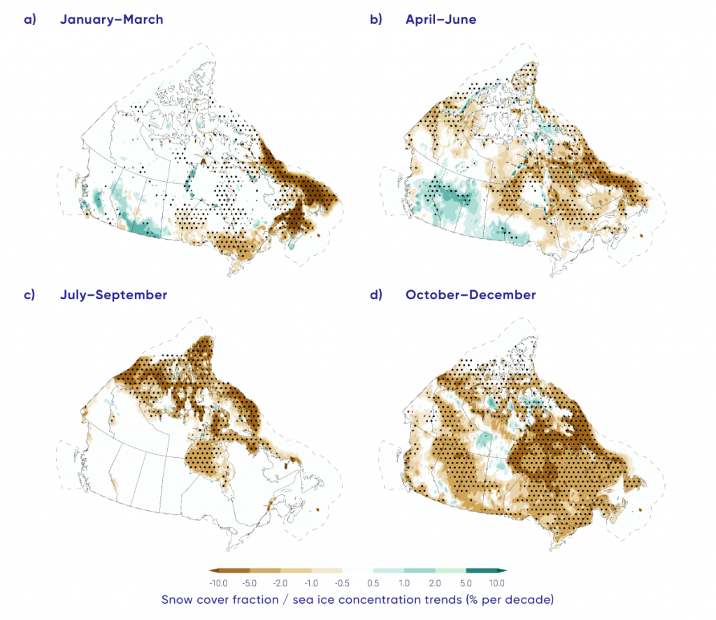
Based on an analysis of multiple datasets covering 1981–2015, SCF (characterized as the proportion of days within each month that snow was present on the ground) decreased by 5% to 10% across most of Canada during most seasons (Mudryk et al., 2018113; see Figure 5.2), notably, for eastern Canada in spring (April/May/June) and most of the Canadian land area in the fall (October/November/December). This loss of snow cover is consistent with previous studies using in situ datasets covering a longer time period (Brown and Braaten, 199820; Vincent et al., 2015189), but the 1981–2015 period is characterized by stronger reductions in snow cover during the snow onset period for eastern Canada in response to enhanced fall warming (consistent with Brown et al., 201825). Decreasing SCF trends over high latitudes of Canada are consistent with documented reductions in annual snow cover duration (SCD; the number of days with snow cover) across circumpolar Arctic land areas of two to four days per decade (approximately 1% to 2% per decade, assuming 250 days mean snow cover) (Brown et al., 201726). Some studies (Derksen and Brown, 201236; Derksen et al., 201637; Brutel-Vuilmet et al., 201327; Hernández-Henríquez et al., 201568; Mudryk et al., 2017115) identified spring snow cover losses slightly stronger than those in Figure 5.2, because different datasets and time periods were considered. Despite these differences, all studies consistently show reductions in spring SCF.

Analysis of surface temperature from a blend of six atmospheric reanalysis datasets showed that warming trends over the 1981–2015 period are found in all Canadian land areas with SCF reductions (Mudryk et al., 2018113). Cooling trends in winter and spring are associated with the regions of increasing SCF (see Figure 5.2). Observations from climate stations in the regions where SCF trends increased over 1981–2015 also show decreased maximum snow depth and SCD over the longer 1950–2012 period (Vincent et al., 2015189), so the positive trends over 1981–2015 reflect nature variability in regional surface temperatures and precipitation.

Figure-5.2

Snow cover fraction and sea ice concentration trends, 1981–2015

Four maps show seasonal trends in snow cover fraction (SCF) and sea ice concentration (SIC) over the 1981–2015 period for Canadian land and marine areas. SCF decreased significantly across southern Ontario in winter, eastern and northern Canada during spring, and nearly all of Canada in autumn (the Canadian land surface is always snow-free in summer). SCF increased significantly in small areas of northern British Columbia, northern Alberta, and northwestern Ontario in spring. SIC decreased significantly over eastern Canadian waters in winter and spring and Canadian Arctic waters in summer and fall.
Figure-5.2

Terrestrial snow cover fraction and sea ice concentration seasonal trends for 1981–2015. Stippling indicates statistical significance (there is only a 10% possibility that such changes are due to chance). Dashed line denotes limit of Canadian marine territory. Changes in sea ice are discussed in Section 5.3.

Source

Figure source: Mudryk et al. (2018)

While SCF information is important for identifying changes in where snow covers the ground, from a water-resources perspective, it is important to understand how much water is stored in the form of snow. This is determined from the pre-melt SWEmax. SWEmax declined by 5% to 10% across much of Canada during the period 1981–2015, according to the multi-dataset analysis shown in Figure 5.3 (Mudryk et al., 2018113). This is consistent with snow depth trends from surface measurements (Brown and Braaten, 199820; Vincent at al., 2015189) and other observational studies (for example, Mudryk et al., 2015114). Increases in SWEmax are evident across parts of British Columbia, Alberta, and southern Saskatchewan. The influences of temperature and precipitation changes need to be separated to understand the driving mechanisms behind trends in SWEmax (Raisanen, 2008141; Brown and Mote, 200924; Mankin and Diffenbaugh, 2014106; Sospedra-Alfonso and Merryfield, 2017166).

Figure-5.3

Trends in maximum snow water equivalent, 1981–2015

Map showing trends in maximum pre-melt snow water equivalent (SWEmax) across Canada, 1981-2015. SWEmax decreased significantly across the Maritimes, southern Quebec and Ontario, and most of Canada north of 55° north latitude. SWEmax increased significantly across parts of British Columbia and southern Saskatchewan.
Figure-5.3

Trends in maximum snow water equivalent (SWEmax) (% per decade) for 1981–2015. Stippling indicates statistical significance (there is only a 10% possibility that such changes are due to chance).

Source

Mudryk et al. (2018).

5.2.2

Projected changes in snow cover

Projections of surface temperatures across Canada for the near-term under a high emission scenario (RCP8.5) show warming in all seasons in the multi-model average (see Chapter 4, Section 4.2.1.3), with concurrent decreases in projected SCF across all of Canada during all seasons (Figure 5.4; Mudryk et al., 2018113). During winter, projected snow cover reductions will be greatest across southern Canada, where temperature increases result in less snowfall as a proportion of the total precipitation. Temperatures will remain sufficiently cold at higher latitudes that winter (January/February/March) SCF in this region is not projected to change in response to warming. During spring, the region of snow sensitivity to temperature forcing is projected to shift north, as snow cover retreats across the boreal forest, sub-Arctic, and high Arctic. This leads to projected negative SCF trends (loss of snow) across these regions during the April through June period. Important differences in spring snow cover projections between emissions scenarios emerge by the end of the century, with stabilized snow loss under a medium emission scenario (RCP4.5) but continued loss under a high emission scenario (RCP8.5) (Brown et al., 201726).

Figure-5.4

Projected snow cover fraction and sea ice concentration trends, 2020–2050

Four maps showing projected seasonal trends in snow cover fraction (SCF) and sea ice concentration (SIC) for the 2020–2050 period for Canadian land and marine areas. SCF decreases are projected across southern Canada in winter, and all of Canada in spring and fall. SIC decreases are projected over eastern Canadian waters in winter, and Arctic waters in spring, summer, and fall.
Figure-5.4

Projected terrestrial snow cover fraction and sea ice concentration seasonal trends (% per decade) for the 2020–2050 period for Canadian land and marine areas. Trends are calculated from the multi-model mean of an ensemble of climate models (Coupled Model Intercomparison Project – CMIP5), using a high emission scenario (RCP8.5). Stippling indicates statistical significance (there is only a 10% possibility that such changes are due to chance).

Source

Mudryk et al. (2018)

Projected changes in SWEmax indicate that reductions will be extensive (5% to 10% per decade through 2050, or a cumulative loss of 15% to 30% over the entire 2020–2050 period) over much of southern Canada, with the greatest changes in the Maritimes and British Columbia (see Figure 5.5). The decreases across the prairies, Ontario, Quebec, and the Maritimes are attributable to increasing temperatures that will shift the proportion of total precipitation that currently falls as snow toward rain (Sospedra-Alfonso and Merryfield, 2017166). (Note that the greatest near-term reductions in SWEmax, according to the climate model projections, will be just south of the Canadian border.) Projected changes in British Columbia are consistent with projected SWEmax reductions in the Western Cordillera (Fyfe et al., 201750). While SWEmax is projected to increase by mid-century in the Eurasian Arctic (Brown et al., 201726), minimal change is projected across high-latitude land areas of Canada because increased snowfall is expected to be offset by increasing temperatures that shorten the snow accumulation season.

Figure-5.5

Projected trends in maximum snow water equivalent, 2020–2050

Map showing projected trends in pre-melt maximum snow water equivalent (SWEmax) across Canada, 2020–2050, for Canadian land areas. Trends are calculated from the multi-model mean of an ensemble climate models (Coupled Model Intercomparison Project - CMIP5), using a high emission scenario (RCP8.5). SWEmax is projected to decrease for all of southern Canada.
Figure-5.5

Projected trends in maximum snow water equivalent (SWEmax, % per decade) for 2020–2050 for Canadian land areas. Trends are calculated from the multi-model mean of an ensemble climate models (Coupled Model Intercomparison Project – CMIP5), using a high emission scenario (RCP8.5). Stippling indicates statistical significance (there is only a 10% possibility that such changes are due to chance).

Source

Mudryk et al., 2018

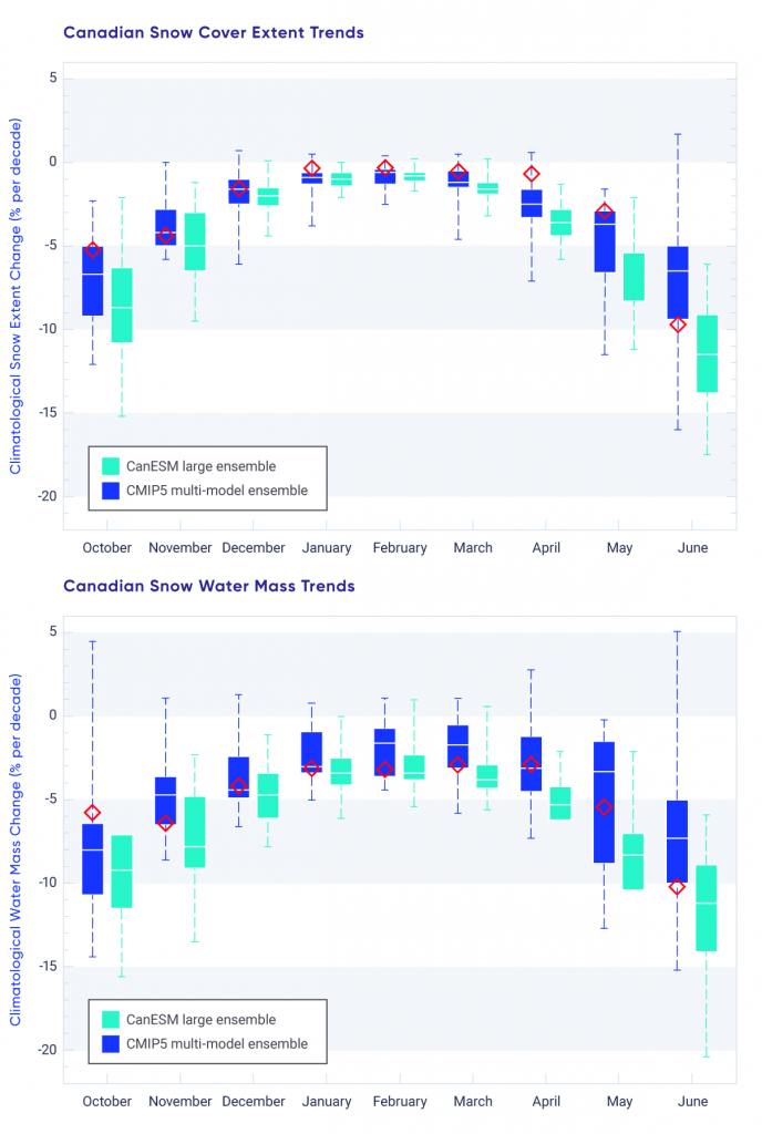
The greatest snow loss across Canada during the 2020–2050 period is projected to occur in the shoulder seasons (October–November and May–June; Thackeray et al., 2016179) (see Figure 5.6). During mid-winter, there is minimal percentage change in projected snow cover extent because winter temperatures across northern regions of Canada will remain cold enough to sustain snow cover and there is greater climatological snow extent in winter, which results in smaller percentage changes (see Figure 5.5). The projected trends are similar to the rate of change already observed during the historical period (see Section 5.2.1). Trends from a large ensemble of simulations from the Canadian Earth System Model (CanESM2) are slightly stronger than the CMIP5 multi-model mean because projected warming is greater in CanESM2 than in the CMIP5 multi-model mean (Thackeray et al., 2016179).

Figure-5.6

Observed (1981–2015) and projected trends in Canadian snow cover extent and snow water mass, 2020–2050

Two box plots showing projected change in monthly snow cover extent and snow mass, 2020–2050, from two climate model ensembles. The projected changes in snow extent and snow mass are negative in all months and these decreases are greatest in the spring and fall. The projected changes to 2050 are similar in magnitude to the observed changes over 1981–2015, which are shown as symbols in the box plots.
Figure-5.6

Monthly projected trends in Canadian snow cover extent (top) and snow water mass (bottom) from the Coupled Model Intercomparison Project (CMIP5) multi-model ensemble (blue) and from the Canadian Earth System Model (CanESM) large ensemble (aqua), under a high emission scenario (RCP8.5). Monthly mean observational trends (1981–2015) from the snow dataset used in Section 5.1.1 are shown in red. Boxes show the 25th–75th percentile range, the horizontal line shows the median, and the dashed whiskers illustrate the minimum and maximum.

Source

Mudryk et al. (2018)


Section summary

In summary, analysis of multiple sources of SCF data from satellite remote sensing and land surface models over the 1981–2015 period show the portion of the year with snow cover decreased across Canada at a rate of 5% to 10% per decade. There is very high confidence in these trends based on consistency among multiple datasets and quantitative relationships with surface temperature trends in which there is also high confidence (see Chapter 4). Seasonal snow accumulation decreased by a rate of 5% to 10% per decade across most of Canada (1981–2015), with the exception of southern Saskatchewan, Alberta, and British Columbia (increases of 2% to 5% per decade), driven by both temperature and precipitation changes. Because of greater uncertainty in sources of data on snow accumulation (compared to those on SCF), we have medium confidence in these trends. It is very likely that snow cover duration will decline to mid-century across Canada as a result of increases in surface air temperature under all emission scenarios. This likelihood assessment is based on the strongly established sensitivity of snow cover to surface temperature in both observations and climate models. Scenario-based differences in projected spring snow cover emerge by the end of the century, with stabilized snow loss for low and medium emission scenarios (RCP2.6 and RCP4.5) but continued snow loss under a high emission scenario (RCP8.5). A reduction of 5% to 10% per decade in seasonal snow accumulation (through 2050) is projected across much of southern Canada; only small changes in snow accumulation are projected across northern regions of Canada because increases in winter precipitation are expected to offset a shorter snow accumulation period. There is greater uncertainty in SWE projections (compared to SCD) because of greater spread in climate model responses due to the competing effects of temperature and precipitation, so there is medium confidence in these results.

5.3

Sea ice

Key Message 1

Perennial sea ice in the Canadian Arctic is being replaced by thinner seasonal sea ice (very high confidence). Summer sea ice area (particularly multi-year ice area) declined across the Canadian Arctic at a rate of 5% per decade to 20% per decade since 1968 (depending on region); winter sea ice area decreased in eastern Canada by 8% per decade.

Key Message 2

It is very likely that increased temperatures under all emissions scenarios will result in continued reduction in sea ice area across the Canadian Arctic in summer and the east coast in winter. Most Canadian Arctic marine regions will be sea ice-free for part of the summer by 2050 (medium confidence), although the region to the north of the Canadian Arctic Archipelago and Greenland will be the last area in the Arctic with multi-year ice present during the summer (very high confidence). Multi-year ice will, therefore, still drift into the Northwest Passage (and present a navigation hazard for shipping) even when the Arctic Ocean is sea ice-free during the summer.

Climate-driven changes to sea ice affect local ecosystems throughout Arctic Canada and influence northern residents through impacts on travelling, hunting, and fishing, with implications for people’s lives, livelihoods, cultural practices, and economic activities. Satellite data show dramatic changes in Arctic sea ice cover during the past 40 years, which are unprecedented over the past 150 years (Walsh et al., 2017190). The once-dominant ice that lasts over at least one complete summer melt season (multi-year ice, MYI) in the Arctic Ocean has been largely replaced by ice that melts completely during the summer (seasonal first-year ice, FYI) (Maslanik et al., 2011109; Comiso, 201233). This change is important because FYI drifts and melts more readily (Tandon et al., 2018176; Stroeve et al., 2012169). Average ice thickness over the Arctic Ocean has decreased considerably (Kwok and Rothrock, 200996; Haas et al., 201066; Laxon et al., 2013102; Richter-Menge and Farrell, 2013142; Kwok and Cunningham, 201595; Tilling et al., 2015181). Since 2007, a series of new record-low Arctic sea ice extents have been recorded in the month of September (when sea ice extent reaches the annual minimum), with a loss rate of approximately 13% per decade relative to the 1981–2010 mean (nsidc.org/arcticseaicenews/; Stroeve et al. 2012169). Concurrent with these changes in ice cover, shipping activity in Canadian Arctic waters has increased over the past decade (Pizzolato et al., 2016134; Dawson et al., 201835). Decreases in sea ice extent are no longer confined to the months of low ice cover (August/September/October), but are now also observed during the once-stable winter season (Serreze et al. 2007151; Parkinson, 2014128).

While the changes in sea ice extent and character across the Arctic are dramatic, there is considerable regional variability. Canadian sea ice areas are composed of portions of the open Arctic Ocean where ice can circulate freely (the western Arctic/Beaufort Sea region), contrasted with the narrow waterways of the Canadian Arctic Archipelago (CAA), where ice is landfast for most of the year. Along the more temperate east coast and in Hudson Bay, the ice melts completely each spring. (Sea ice does not occur on the Pacific coast.)

5.3.1

Observed changes in sea ice

Estimates of total ice and MYI area within Canadian Arctic waters are available from the Canadian Ice Service Digital Archive (CISDA), which is an integration of a variety of datasets, including satellite measurements, surface observations, airborne and ship reports, and operational model results (see Canadian Ice Service, 200730 and Tivy et al., 2011a182 for complete details). This record has been shown to provide more accurate estimates of sea ice concentration (SIC) in Canadian waters compared to satellite passive microwave estimates (Agnew and Howell, 20032). Analysis of seasonally averaged trends in SIC over the 1981–2015 period (selected to match the period of snow datasets described in Section 5.2.1) found reductions over Canadian waters in all seasons (see Figure 5.2). Regions with the strongest SIC declines were eastern Canadian waters in winter and spring, and the CAA and Hudson Bay in summer and fall. SIC trend patterns are closely associated with warming patterns during the seasons of ice onset and growth (from October through March). However, dynamic effects (such as wind, which redistributes sea ice) also influence the observed ice reductions in spring and summer (Mudryk et al., 2018113).

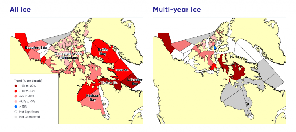
The CISDA archive also extends the record of total and MYI back to 1968, almost 10 years earlier than coverage by satellite passive microwave observations. Between 1968 and 2016, sea ice area, averaged over the summer period, has decreased significantly in almost every region of the Canadian Arctic, by up to 20% per decade in some regions (e.g., the Hudson Strait and Labrador Sea; see Figure 5.7). Compared with trends computed over the periods 1968–2008 (Tivy et al., 2011a182) and 1968–2010 (Derksen et al., 201236), more regions are now experiencing significant decreases, and the rate of decline is stronger in all regions except Hudson Bay. The largest declines in MYI have occurred in the CAA (approximately 9% per decade) and Beaufort Sea (approximately 7% per decade).

Figure-5.7

Trends in Arctic summer total ice and multi-year ice, 1968–2016

Two maps show trends in (1) sea ice area and (2) MYI area for regions of the Canadian Arctic, 1968–2016. Negative (declining) trends in sea ice area are strongest for the Labrador Sea, Hudson Strait, Davis Strait, Baffin Bay, and the western Beaufort Sea. Negative trends in MYI are strongest for the eastern Canadian Arctic Archipelago and western Beaufort Sea.
Figure-5.7

Trends in summer total ice (all ice types) (left) and multi-year ice (MYI, right) area from 1968 to 2016. Summer is defined as June 25 to October 15 for the Beaufort Sea, CAA, and Baffin Bay regions, and from June 18 to November 19 for Hudson Bay, Hudson Strait, Davis Strait, and Labrador Sea, consistent with Tivy et al. (2011a) and Derksen et al. (2012). Only trends significant at the 5% level (there is only a 5% possibility that the trend is due to chance) are shown.

Source

Canadian Ice Service Digital Archive; Mudryk et al. (2018)

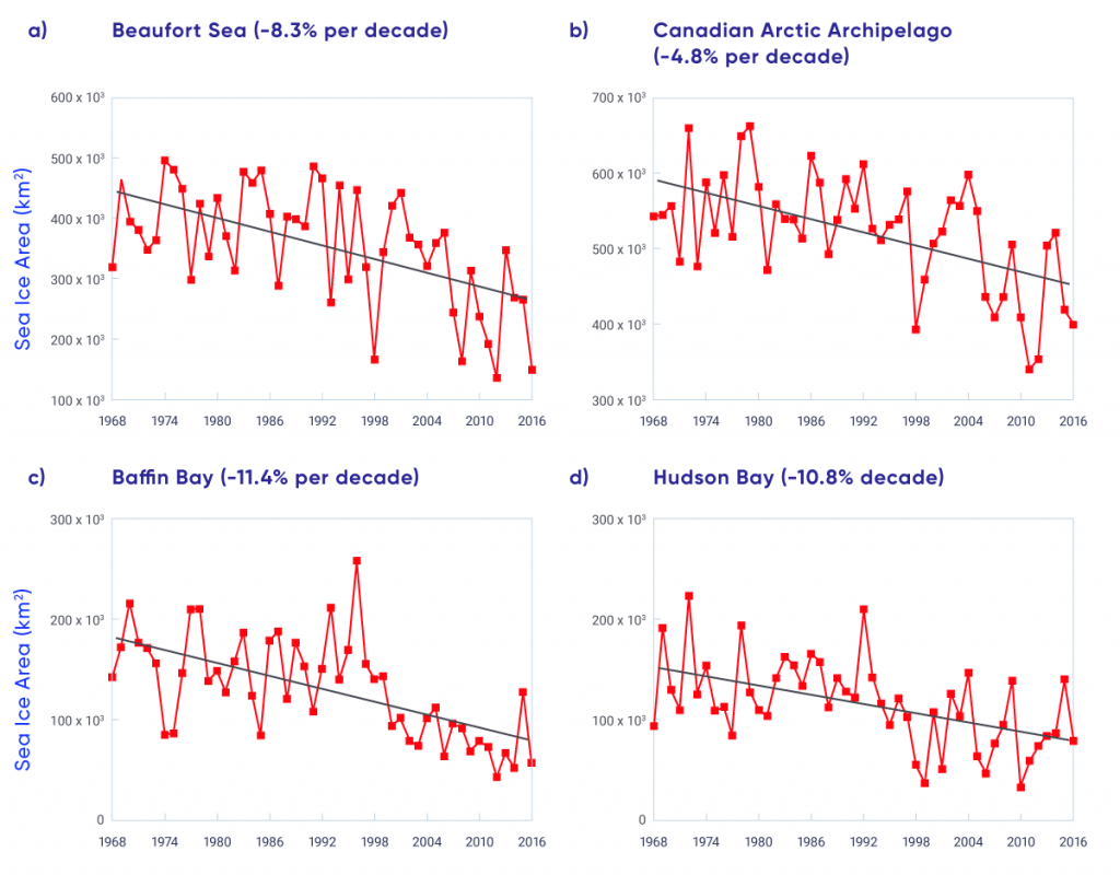
While there are high year-to-year differences due to natural variability, time series of sea ice area (see Figure 5.8) clearly show negative trends. The Beaufort Sea experienced record-low sea ice area in 2012, becoming virtually ice free near the end of the melt season (Figure 5.8a; Babb et al., 20168). This was nearly repeated in 2016. The CAA had record-low ice years in 2011 and 2012, eclipsing the previous record set in 1998 (Figure 5.8b; Howell et al., 201375). Baffin Bay has experienced consistently low sea ice area since 1999 (Figure 5.8c), while Hudson Bay sea ice area has declined since the mid-1990s (see Figure 5.8d; Tivy et al., 2011b183; Hochheim and Barber, 201469). Modelling has demonstrated that the recent extreme lows in Arctic SIC would not have occurred without anthropogenic climate change (see Box 5.1).

Figure-5.8

Arctic summer total sea ice area, 1968–2016

Four line plots show the time series of summer sea ice area for the Beaufort Sea, Canadian Arctic Archipelago, Baffin Bay, and Hudson Bay, 1968–2016. Trends are negative for each region (declining by 8.3% per decade for the Beaufort Sea; 4.8% per decade for the Canadian Arctic Archipelago; 11.4% per decade for Baffin Bay, and 10.8% per decade for Hudson Bay).
Figure-5.8

Time series of summer total sea ice area for the (a) Beaufort Sea, (b) Canadian Arctic Archipelago (CAA), (c) Baffin Bay, and (d) Hudson Bay regions from 1968 to 2016.

Source

Canadian Ice Service Digital Archive; Mudryk et al. (2018)

The decline of sea ice across the Canadian Arctic is driven by increasing spring air temperature and resulting increases in the length of the melt season. This results in more open water, increased absorption of solar radiation (which further contributes to ice melt), increased water temperature, and delayed fall freeze-up (Howell et al., 2009a73; Tivy et al., 2011a182; Stroeve et al., 2014168; Parkinson, 2014128). Changes in sea ice cover are also driven by atmospheric circulation. The Beaufort Sea was once a region where ice would thicken and age before being transported to the Chukchi Sea and recirculated in the Arctic (Tucker et al., 2001185; Rigor et al., 2002143), but now the region has become a considerable contributor to the Arctic’s MYI loss (Kwok and Cunningham, 201094; Maslanik et al., 2011109; Krishfield et al., 201493; Galley et al., 201652). Ice is still being sequestered from the Canada Basin (one of the two ocean basins in the Arctic Ocean) and transported through the Beaufort Sea during the summer months, but this ice is now younger and thinner and melts en route to the Chukchi Sea (Howell et al., 2016a70). The CAA was also a region with historically heavy MYI throughout the melt season, but MYI conditions have become lighter in recent years (see Figure 5.7; Howell et al., 201572).

Arctic sea ice thickness has declined in recent years, largely associated with a reduction and thinning of the MYI fraction (e.g., Kwok and Rothrock, 200996; Haas et al., 201066; Laxon et al., 2013102; Richter-Menge and Farrell, 2013142; Kwok and Cunningham, 201595; Tilling et al., 2015181). These studies indicate thickness declines are greater in the Beaufort Sea compared with the north-facing coast of the CAA, which still contains some of the thickest sea ice in the world (Haas and Howell, 201565). Unfortunately, the spaceborne sensors used to obtain sea ice thickness information over the Arctic Ocean are not of sufficient spatial resolution to provide thickness estimates within the narrow channels of the CAA. Although there are only four locations with consistent records and point measurements may not capture regionally representative conditions, the Canadian Ice Service record of in situ landfast ice thickness represents one of the longest datasets in the Arctic, spanning over five decades. Maximum ice thickness has declined significantly at three sites in the CAA (Cambridge Bay, Eureka, and Alert), with decreases ranging from 3.6 to 5.1 cm (± 1.7 cm) per decade from the late 1950s to 2016 (Howell et al., 2016b74). No significant trend was found at Resolute, a result that differs from an earlier study by Brown and Cote (1992), which reported a significant increase in maximum ice thickness at Resolute over the 1950–1989 period.

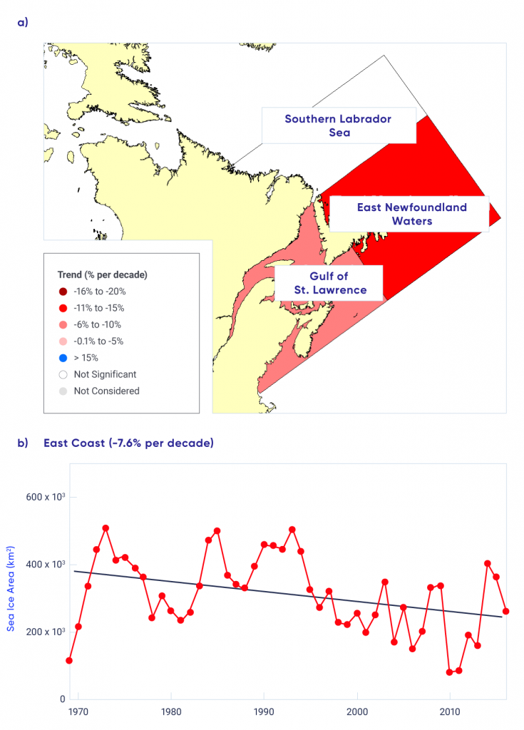
Sea ice along the east coast of Canada is seasonal, with ice melting completely each spring. A robust indicator of change is winter season sea ice area, defined as the average from January through March of each year. The rate of decline between 1969 and 2016, determined from the CISDA for the entire east coast region, is 7.5% per decade (statistically significant at the 1% level; there is only a 1% possibility that the decline is due to chance; see Figure 5.10). This is consistent with the passive microwave time series, which indicates a decline of 9.5% per decade over the 1979–2015 period (Peng and Meier, 2017130). There is regional variability within the east coast region, as the rate of decline for the Gulf of St. Lawrence (8.3% per decade) is less than that for eastern Newfoundland waters (10.6% per decade), while the decline for the southern Labrador Sea is not statistically significant at the 5% level (there is a possibility of more than 5% that the decline is due to chance; see Figure 5.10). Years with extensive ice cover are more prominent before 1995, but the region has experienced recent heavy ice years as well (in 2014 and 2015). Sea ice variability in this region is driven largely by temperature and atmospheric circulation (i.e., winds) associated with the Arctic Oscillation (also called the Northern Annular Mode [see Chapter 2, Box 2.5]; Deser and Tang, 200839; Peterson et al., 2015133).

Figure-5.10

East coast winter season sea ice area trends, 1969–2016

This is a two-panel figure. The top panel is a map showing trends in sea ice area for subregions of eastern Canadian waters, 1969 to 2016. Negative trends are strongest for east Newfoundland waters. The bottom panel is a time series graph of sea ice area for the entire east coast region, 1969 to 2016, with a negative (declining) trend of 7.6% per decade.
Figure-5.10

(a) Map of average January–March sea ice area trends for subregions of the east coast and (b) time series of average January–March sea ice area trends for the entire region, 1969–2016.

Source

Canadian Ice Service Digital Archive; Mudryk et al. (2018)

5.3.2

Projected changes in sea ice

The narrow channels in Canadian Arctic waters are poorly represented by the coarse spatial resolution of climate models. While uncertainty in model projections is therefore higher for the CAA than for the pan-Arctic, evaluation of historical simulations shows the CMIP5 multi-model ensemble (see Chapter 3, Box 3.1) still provides a quantitative basis for projecting future sea ice conditions (Laliberté et al., 201697). Under a high emission scenario (RCP8.5), the CMIP5 multi-model projections indicate widespread reductions in SIC for the ice melt (summer) and ice formation (fall) seasons (Mudryk et al., 2018113; see Figure 5.4). For the east coast, virtually ice-free conditions during the winter months are projected by mid-century under a high emission scenario (RCP8.5) with uncertainty in these projections due to potential changes in the transport of sea ice from the Arctic to the east coast (Loder et al., 2015104).

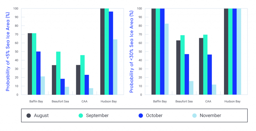
The probability and timing of future sea ice–free conditions are sensitive to the definition of ‘ice-free’ (Laliberté et al., 201697). When using a threshold of 5% ice area, there is a 50% probability that all Canadian regions will be sea ice–free in September by 2050 under a high emission scenario (RCP8.5; see Figure 5.11). The probability that all regions will be ice free is similar for August, but lower for October and November. Hudson Bay, which is already largely ice free in August and September, has a high probability of being ice free for four consecutive months (August through November) by 2050. Using a definition of 30% ice area, more persistent ice-free conditions are projected. Baffin Bay is projected to be ice free for August through October, and the Beaufort Sea and the CAA may be ice free in August and September by 2050.

Figure-5.11

Probability of sea ice–free conditions by 2050

Two column graphs show the probability that a region will be free of sea ice in August, September, October, or November by 2050 using a threshold of 5% sea ice area (first graph) and 30% sea ice area (second graph). Regions shown are Baffin Bay, Beaufort Sea, Canadian Arctic Archipelago (CAA), and Hudson Bay. Probabilities of ice-free conditions during August to November range from 10% to 50% in the Beaufort Sea and CAA to 50% to 90% for Baffin Bay and Hudson Bay. Probabilities are even higher for the 30% ice area threshold compared to the 5% threshold.
Figure-5.11

Probability of sea ice–free conditions by 2050 under a high emission scenario (RCP8.5) from the Coupled Model Intercomparison Project (CMIP5) multi-model mean using a definition of ice-free conditions of 5% (left) and 30% (right) sea ice area.

Source

Mudryk et al. (2018)

The likelihood of summer ice-free conditions in the central Arctic is connected to the magnitude of projected global temperature increases, with a much greater probability of ice-free conditions for 2°C global warming compared to 1.5°C (Jahn, 201878; Sigmond et al., 2018156). The area to the north of the CAA and Greenland will be the last refuge for summer sea ice (including MYI) in the Arctic during the summer (Wang and Overland, 2012193; Laliberté et al., 201697), so ice will still drift into the Northwest Passage, where it will present a navigation hazard for shipping, even when the Arctic Ocean is sea ice–free during the summer (see FAQ 5.1: Where will the last ice area be in the Arctic?).


Section summary

In summary, the Arctic sea ice environment has changed profoundly over recent decades (Barber et al., 201710). Perennial sea ice that survives the summer melt is being replaced by thinner seasonal sea ice that melts in the summer. Summer sea ice area (particularly MYI) declined across the Canadian Arctic by 5% to 20% per decade (1968–2016, depending on region); winter sea ice area decreased in eastern Canada (by 7.6% per decade, 1969–2016). There is very high confidence in these trends, which are derived by trained analysts from Canadian Ice Service ice charts that provide region-specific sea ice information. It is very likely that continued reductions in summer and fall sea ice across the Canadian Arctic, and winter sea ice in eastern Canadian waters, will result from increased temperatures under all emission scenarios. Most Canadian Arctic marine regions could be sea ice–free for at least one month in the summer by 2050 (high confidence) based on simulations from CMIP5 models. There is very high confidence that the region to the north of the CAA and Greenland will be the last area where thick MYI will be present in the Arctic during the summer. Current understanding of sea ice dynamics, based on satellite observations, indicates this MYI will continue to drift into Canadian waters.

5.4

Glaciers and ice caps

Key Message 1

Canada’s Arctic and alpine glaciers have thinned over the past five decades due to increasing surface temperatures; recent mass loss rates are unprecedented over several millennia (very high confidence). Mass loss from glaciers and ice caps in the Canadian Arctic represent the third largest cryosphere contributor to global sea level rise (after the Greenland and Antarctic ice sheets) (very high confidence).

Key Message 2

Under a medium emission scenario, it is projected that glaciers across the Western Cordillera will lose 74% to 96% of their volume by late century (high confidence). An associated decline in glacial meltwater supply to rivers and streams (with impacts on freshwater availability) will emerge by mid-century (medium confidence). Most small ice caps and ice shelves in the Canadian Arctic will disappear by 2100 (very high confidence).

Canada’s landmass supports approximately 200,000 km2 of ice, which includes glaciers and ice caps in western Canada, the Canadian Arctic Archipelago (CAA), and northern Labrador (Radic et al., 2014140; Clarke et al., 201532). These glaciers are responding to long-term climate changes since the Little Ice Age, as well as the anthropogenic rapid warming of recent decades. The largest ice caps are located in Queen Elizabeth Islands and Baffin Island of the Canadian Arctic. Because they drain to the Arctic Ocean, these ice caps represent the greatest potential contribution from Canadian territory to sea level increases (Radic et al., 2014140). Mountain glaciers of western Canada cover a much smaller area and have less potential to affect global sea levels. However, they are an important source of meltwater runoff, as melt from these glaciers is a significant contributor to summer streamflow in river systems (Jost et al., 201281; Naz et al., 2014122; Bash and Marshall, 201413). The loss of mountain glaciers can therefore influence how much water is available, and when, in downstream areas that can extend far from the source regions.

A key measure of health for glaciers and ice caps is surface mass balance, the difference between annual mass gained through snow accumulation and mass lost due to melt runoff. In the relatively dry Canadian Arctic, surface mass balance is determined primarily by the duration and intensity of the summer melt season (Koerner, 200585), while glaciers in more temperate regions of Canada are also influenced significantly by year-to-year variations in snowfall. Remote sensing measurements generally cannot be used to directly estimate mass balance, with the exception of very coarse resolution gravimetric measurements from the NASA GRACE mission (approximately 450 km × 450 km), but remote sensing does contribute valuable information on the melt/freeze state (Wang et al., 2005192), changes in ice thickness (Gray et al., 201659; Krabill et al., 200292; Berthier et al., 201418), and glacier motion and iceberg calving (Strozzi et al., 2008170, van Wychen et al., 2016186, Gray et al., 200160). For larger regions, models can be used to estimate mass balance (Lenaerts et al., 2013103; Gardner et al., 201154). Long-term records of surface mass balance measurements from a small number of Canadian glaciers are available through the World Glacier Monitoring Service (<http://wgms.ch/latest-glacier-mass-balance-data/>). Acquiring surface measurements for the determination of glacier mass balance is logistically difficult, so only selected glaciers in the CAA and western Cordillera are monitored (see Figure 5.13).

5.4.1

Observed changes in glaciers and ice caps

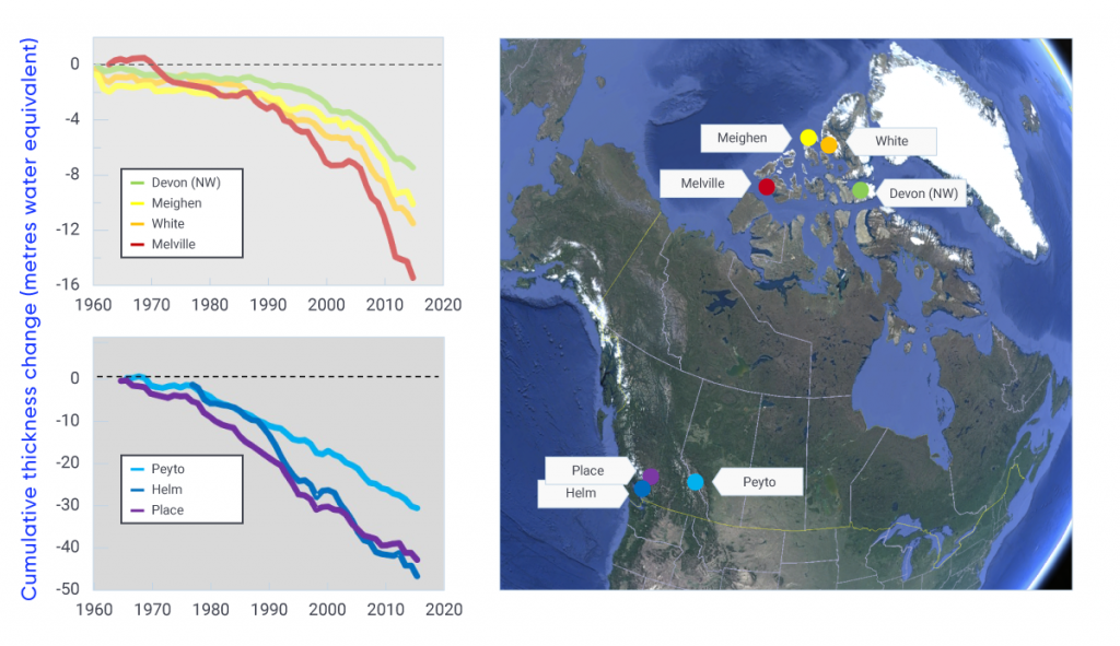
Climate warming, combined with periods of reduced precipitation in Western Canada, has contributed to total thinning of glaciers in the southern Cordillera by 30 to 50 m since the early 1980s (see Figure 5.13) (Zemp et al., 2015197). By the mid-1980s, glaciers in Garibaldi Provincial Park, southern British Columbia, had contracted in area by 208 km2 since the Little Ice Age maximum extent of 505 km2, with accelerated shrinkage by another 52 km2 (or 7% of the Little Ice Age maximum) by 2005 (Koch et al., 200984). Glacier extent at several sites in the central and southern Canadian Rocky Mountains decreased by approximately 40% from 1919 to 2006 (Tennant et al., 2012178). Glaciers of the Columbia Icefield, in the Canadian Rocky Mountains, also experienced dramatic changes from 1919 to 2009, losing 22.5% of total area while retreating more than 1.1 km on average (Tennant and Menounos, 2013177). Aerial photography shows that all glaciers in British Columbia’s Cariboo Mountains receded over the 1952–2005 period, with a loss of approximately 11% in surface area (Beedle et al., 201515). In eastern Canada, small alpine glaciers in the Torngat Mountains, Labrador (see Figure 5.13 for location) shrunk by 27% between 1950 and 2005, with current thinning rates as high as 6 m per year across the 22 km2 of glaciers that remain in this area (Barrand et al., 201712).

Figure-5.13

Cumulative thickness change at long-term glacier monitoring sites in Canada

Figure-5.13

Map shows location of monitoring sites in the Canadian Arctic Archipelago and the Western Cordillera (image courtesy of Google Earth). Graphs show change in cumulative thickness of reference glaciers in the Canadian high Arctic (top left) and Western Cordillera (bottom left) since the early 1960s. Note the difference in y-axis scale between graphs.

Source

Mass balance data for Devon (NorthWest), Meighen, Melville, and all sites in the Western Cordillera are from the Geological Survey of Canada Archives, and data from the White Glacier were obtained from Trent University (1960-2012; G. Cogley) and University of Ottawa (2013-2015; L. Copland).

Glaciers and ice fields covering approximately 10,000 km2 of the Yukon have decreased in area by approximately 22% between 1957 and 2007, and thinned by 0.78 m water equivalent (90% uncertainty range 0.44 to 1.12 m per year) contributing 1.12 mm (90% uncertainty range 0.63 to 1.61 mm) to global sea level over this period (Barrand and Sharp, 201011). Mass balance of glaciers, measured at three monitoring sites in Alaska (all within 300 km of the Kluane ice field, Yukon) indicate a rapid change from positive to negative glacier mass balance in this region beginning in the late 1980s (Wolken et al., 2017195).

Long-term in situ glacier monitoring indicates a trend of significant loss of mass for glaciers and ice caps in the CAA beginning in the early 1990s (see Figure 5.13). Acceleration of glacier thinning in this region in the mid-2000s coincided with increases in summer warming driven by the advection of warm air masses to the Arctic from more southerly latitudes (Sharp et al., 2011154; Mortimer et al., 2016112). Based on satellite measurements and surface mass-budget models, total mass loss from glaciers and ice caps in the CAA has increased more than two-fold, from 22 gigatonnes (Gt) per year between 1995 and 2000 (Abdalati et al., 20041), to 60 Gt per year (90% uncertainty range 52 to 66 Gt per year) over the 2004–2009 period (Gardner et al., 201353), and 67 Gt per year (90% uncertainty range 61 to 73 Gt per year) over the 2003–2010 period (Jacob et al., 201277), with mass losses continuing to accelerate to 2015 (Harig and Simons, 201667). According to the most recent assessments of regional glacier change, glacier melting in the CAA has contributed 0.16 mm per year to global sea-level rise since 1995, 23% of the contribution of the Greenland ice sheet and 75% of the Antarctic Ice Sheet (Gardner et al., 201353; Shepard et al., 2012155; Sharp et al., 2016153).

The Barnes Ice Cap on Baffin Island, the last remnant of the Laurentide Ice Sheet that covered most of Canada during the last glaciation, lost 17% of its mass from 1900 to 2010 (Gilbert et al., 201655). Approximately 10% of the total area of ice in the CAA is composed of small, stagnant ice caps (the oldest are less than 3000 years old), located almost entirely under the regional equilibrium line altitude, meaning they do not have an accumulation zone and experience net thinning across their entire area in most years. These ice caps are shrinking rapidly (Serreze et al., 2017152) and fragmenting (Burgess, 201728), with many expected to completely disappear within the next few decades. Of similar age to the small ice caps are the ice shelves of northern Ellesmere Island, which are composed of floating glacier ice and/or very thick old sea ice. These ice shelves have decreased in area by about 90% since 1900 (with more than 50% of that loss since 2003) and are expected to survive for only the next decade or two (Mueller et al., 2017116).

Like many glaciers in the world, Canada’s glaciers are out of equilibrium with current climatic conditions and will continue to lose mass for the foreseeable future. Summer warming in the Arctic has driven extreme melting of ice caps and glaciers over the past two decades, resulting in this region becoming the most significant cryosphere contributor to global sea-level rise after the Greenland and Antarctic ice sheets.

5.4.2

Projected changes in glaciers and ice caps

Climate model projections indicate that western Canada and the western United States together (grouped together in many studies because of their similar mountainous domain) could lose approximately 85% (90% uncertainty range 74% to 96%) of the 2006 volume of glaciers by the end of the century under a medium emission scenario (RCP4.5). Under a high emission scenario (RCP8.5), this loss could exceed 95% (Radic et al., 2014140). Glaciers in the coastal ranges of western Canada are predicted to lose 75% (90% uncertainty range 65% to 85%) of their 2005 ice area and 70% (90% uncertainty range 60% to 80%) of their volume by 2100 based on the mean of four emission scenarios (RCP2.6, 4.5, 6.0, 8.5) (Clarke et al., 201532). Glaciers in the western Canadian interior are projected to lose more than 90% of the 2005 volume under all scenarios except a low emission scenario (RCP2.6) (Clarke et al., 201532). These changes, in combination with the projected loss of alpine snow cover, will impact regional water resources (Fyfe et al., 201750; see Chapter 6, Section 6.2). Glacier-fed rivers may experience periods of increased discharge due to greater meltwater contributions in a warmer climate, but this response is finite, and glacier mass loss associated with warming is projected to result in reduced summer streamflow by mid-century (Clarke et al., 201532). The rate and timing of this transition will have important consequences for stream and river water quality and temperature, and for the availability of water for human uses such as hydro-electricity generation and agriculture.

Regional land ice models project that glaciers and ice caps in the Canadian Arctic will lose 18% of their total mass by 2100 (Radic et al., 2014140; relative to a baseline mass reference estimated by Radic and Hock, 2011) under a medium emission scenario (RCP4.5), equivalent to 35 mm of global sea-level rise (Lenaerts et al., 2013103; Marzeion et al., 2012108). This loss of land ice volume in Arctic Canada by 2100 will contribute 41 mm of sea-level equivalent (90% uncertainty range 26 to 56 mm) under RCP4.5, and 57 mm of sea-level equivalent (90% uncertainty range 39 to 75 mm) under a high emission scenario (RCP8.5) (Radic et al., 2014140). Densification of high-elevation firn (partially compacted granular snow that is the intermediate stage between snow and glacial ice) has reduced or eliminated the internal storage capacity of the larger (more than 2000 km2) ice caps in this region, thus increasing their sensitivity to future warming (Noël et al., 2018124). Based on the trajectories of observed loss over recent decades, many of the remaining small ice caps (less than 2000 km2) and ice shelves in the Canadian Arctic are expected to disappear by 2100.


Section summary

In summary, Canada’s Arctic and alpine glaciers have thinned over the past three to five decades, due to increasing surface temperatures (very high confidence). While spatial sampling is sparse, these long-term trends in glacier thickness change have been measured annually following standardized protocols and agree with independent remote sensing and model-based approaches. Multiple assessments using satellite data and models show that mass loss from glaciers and ice caps in the Canadian Arctic represents the largest cryosphere contributor to global sea-level rise after the Greenland and Antarctic ice sheets (very high confidence). Based on a regional mass balance model forced by future climate scenarios, glaciers across the Western Cordillera are projected to lose up to 85% of their volume by the end of the century (high confidence). This will lead to a decline in glacial meltwater supply to rivers and streams, although there is only medium confidence in the absolute impacts on freshwater availability because of multiple other contributors to projected streamflow changes (see Chapter 6, Section 6.2). Based on output from various independent models, glaciers and ice caps in the Canadian Arctic will lose 18% of their total mass by the end of the century, and so will remain important contributors to global sea-level rise beyond 2100 (high confidence). Small ice caps and ice shelves in the Canadian Arctic are shrinking rapidly. Based on observed changes in recent decades, and ice cap and ice shelf sensitivity to projected temperature increases, most are expected to disappear well before 2100 (very high confidence).

5.5

Lake and river ice

Key Message 1

The duration of seasonal lake ice cover has declined across Canada over the past five decades due to later ice formation in fall and earlier spring breakup (high confidence). Seasonal maximum lake ice cover for the Great Lakes is highly variable since 1971 (very high confidence), with no significant trend.

Key Message 2

Spring lake ice breakup will be 10 to 25 days earlier by mid-century, and fall freeze-up 5 to 15 days later, depending on the emissions scenario and lake-specific characteristics such as depth (medium confidence).

Canada is a lake-rich country, particularly across the north, with approximately 20% to 25% of the Arctic coastal lowlands covered by lakes (Duguay et al., 200344). Therefore, the timing of lake and river ice freeze-up and breakup (known as ice phenology) and ice thickness are important indicators of climate variability and change. Ice phenology is sensitive to changes in air temperature, whereas changes in ice thickness are linked to changes in both air temperature and snowfall. Due to the insulating properties of snow, the timing of snow accumulation on new ice and the seasonal accumulation of snow influence ice thickness. In situ records of ice cover across much of Canada are limited, because surface-based ice monitoring is not practical in many regions, so satellite remote sensing is commonly used to monitor lake and river ice (Howell et al., 200971).

Changes to ice phenology and thickness influence the role that lakes play in regional energy and water cycles (Rouse et al., 2005147). Ice cover also has strong effects on lake biogeochemical processes in cold regions: changes in the ecological productivity of high Arctic lakes on Ellesmere Island are predominantly determined by variations in ice cover duration (Griffiths et al., 201762). Reductions in ice cover may also allow greater emissions of methane (a greenhouse gas) from Arctic lakes (Greene et al., 201461; Tan and Zhuang, 2015175). The importance of ice cover to ecosystems is not limited to the Arctic. For instance, earlier ice melt across the Great Lakes is linked to turbidity and phytoplankton activity through enhanced wind-induced mixing (Bai et al., 20159). Seasonal roads across frozen lakes serve as a critical supply lines to remote communities and mines during winter months, while stable lake and river ice is a necessity for safe winter season recreation and travel for residents of northern communities.

5.5.1

Observed changes in lake and river ice

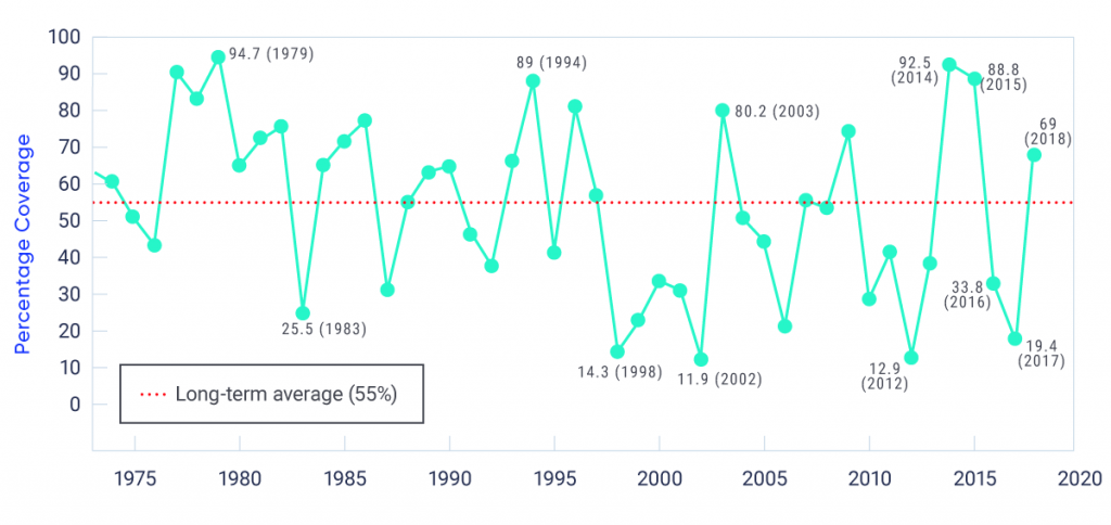
Surface observations show that ice breakup is occurring earlier, and freeze onset later, across small lakes in southern Quebec, Ontario, Manitoba, and Saskatchewan (Brown and Duguay, 201022). A significant declining trend in annual maximum ice cover was observed for the Laurentian Great Lakes over the 1973–2010 period (71% decline for all of the Laurentian Great Lakes), with the largest declines occurring in Lake Ontario (88%), Lake Superior (79%), and Lake Michigan (77%) (Wang et al., 2012191). Heavy ice years in 2014, 2015, and 2018, however, result in no trend over the full 1973–2018 period (Figure 5.14). The large year-to-year variation is associated with the Arctic Oscillation/North Atlantic Oscillation (AO/NAO) and El Niño–Southern Oscillation (ENSO) (see Chapter 2, Box 2.5). For example, the record-breaking low in maximum ice cover in the winter of 2011/2012 occurred during a strong positive-phase AO/NAO and the cold phase of ENSO (La Niña event) (Bai et al., 20159). Whether variable ice cover contributes to observed increases in water temperature in the Laurentian Great Lakes is a topic under debate. Recent findings suggest that changes in winter lake ice cover play only a minor role in the observed warming trend (Zhong et al., 2016202), whereas ice cover duration was linked to summer surface water temperature (particularly in nearshore areas) when the lakes were examined at a finer spatial scale (Mason et al., 2016110).

Figure-5.14

Laurentian Great Lakes annual maximum ice cover, 1973–2018

Line graph shows the time series of annual maximum ice cover (expressed as a percentage) for the Laurentian Great Lakes, from 1973 to 2018. There is no clear trend in the data, and a high degree of interannual variability.
Figure-5.14

Laurentian Great Lakes annual maximum ice cover (%) (1973–2018). Red dashed line indicates the long-term average.

Source

NOAA Great Lakes Environmental Research Laboratory, https://www.glerl.noaa.gov/data/ice/

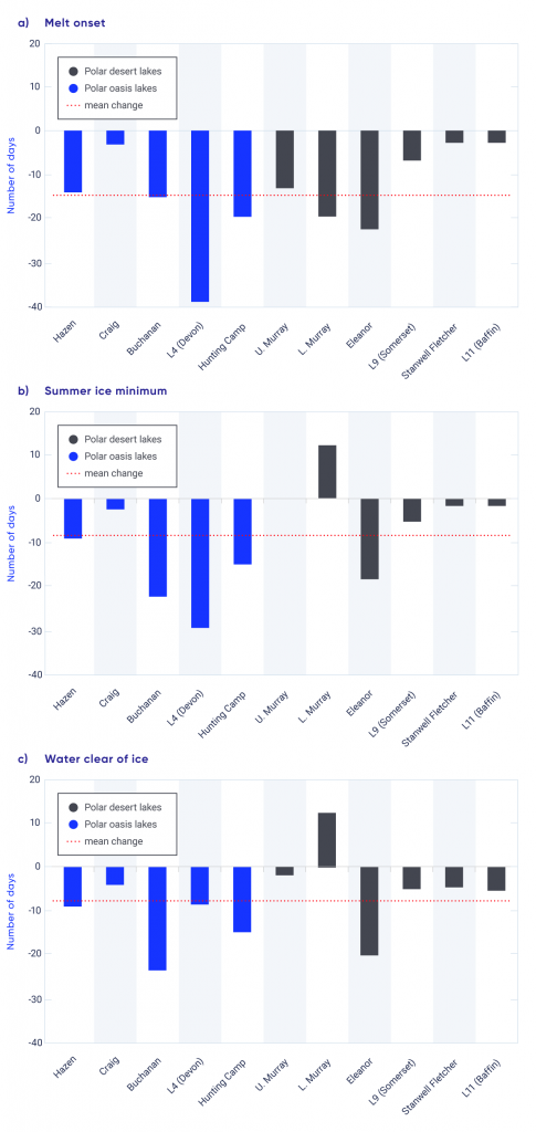
Satellite measurements show that lakes in Arctic Canada have also been experiencing an earlier ice minimum (the last date of floating ice cover on the lake surface) and an earlier date when the water is clear of ice (see Figure 5.15; see also Duguay et al., 200645; Prowse, 2012135; Cooley and Pavelsky, 201634). These changes are consistent with a recent circumpolar assessment, which showed that approximately 80% of Arctic lakes experienced declines in ice cover duration from 2002 to 2015, due to both a later freeze-up and an earlier breakup (Du et al., 201741). Results from northern Alaska (which are likely similar to those in northwestern Canada) show that lake ice has begun to thin in recent decades (Alexeev et al., 20163). From 1992 to 2011, approximately one-third of shallow lakes in which the entire water volume historically froze to the bed by the end of winter had changed to floating ice (Arp et al., 20127; Surdu et al., 2014173). Canada’s northernmost lake, Ward Hunt Lake (located on Ward Hunt Island), had maintained stable, continuous year-round ice cover for many decades until very warm summers of 2011 and 2012, when the ice cover fully melted (Paquette et al., 2015127). This loss of inland perennial freshwater ice cover occurred nearly simultaneously with the collapse of the nearby Ward Hunt ice shelf (Mueller et al., 2009117; Veillette et al., 2010188). Analysis of a 15-year time series (1997–2011) of radar and optical satellite imagery provides further evidence that some lakes in the central and eastern Canadian high Arctic are transitioning from continuous (year-round) to seasonal ice cover (Surdu et al., 2016174).

It is difficult to provide an assessment of river ice changes across Canada because of sparse observations and a lack of recent assessments of the available data. There is evidence of earlier river ice breakup, consistent with increases in surface temperature (Prowse, 2012135). However, the impact that climate-driven changes in ice phenology and thickness, combined with changing seasonal flow regimes (see Chapter 6, Section 6.2) and the influence of hydraulic processes (i.e., changing ice strength), will have on ice jams and flood events is not fully understood (Beltaos and Prowse, 200916).

Figure-5.15

Changes in ice cover for selected lakes in the Canadian high Arctic, 1997–2011

Three column graphs showing change in melt onset, summer ice minimum, and water clear of ice date for 11 lakes in the Canadian high Arctic, expressed in days of change between 1997 and 2011. In nearly all cases, all three events occurred earlier in the season.
Figure-5.15

Number of days earlier (negative numbers) or later (positive numbers) of (a) melt onset, (b) summer ice minimum, and (c) date that water is clear of ice for selected lakes in the central and eastern Canadian high Arctic from 1997 to 2011. Number of days’ change is reported relative to the 1997–2011 mean date (from remote sensing observations). Lakes in polar-oasis (relatively high annual precipitation) environments are shown as blue bars and lakes in polar-desert environments (relatively low annual precipitation) are shown as black bars. The red dashed line indicates the 1997–2011 mean change.

Source

Surdu et al., 2016

5.5.2

Projected changes in lake and river ice

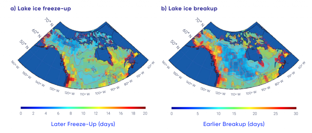
Changes in lake ice can be projected only indirectly, because lake models are not embedded within global climate models and individual lakes are not spatially resolved. When forced by a future climate under a medium emission scenario (RCP4.5), lake ice models project that spring breakup will occur between 10 and 25 days earlier by mid-century (compared with 1961–1990), and freeze-up will be five to 15 days later across Canada (Brown and Duguay, 201123; Dibike et al., 201240) (Figure 5.16). This results in a reduction of ice cover duration of 15 to 40 days for much of the country. More extreme reductions of up to 60 days are projected in coastal regions. The range in projected changes is due to regional variability in temperature and snowfall changes, and to lake-specific variables such as size and depth. The Laurentian Great Lakes can be resolved by lake models if the projected climate forcing data are downscaled. This approach has identified consistent results, with reduced ice cover duration of between 25 to 50 days across the Laurentian Great Lakes by mid-century, due to both later freeze-up and earlier melt (Gula and Peltier, 201263). Mean seasonal maximum ice thickness is projected to decrease by 10 to 50 cm by mid-century, with a more pronounced decrease in the eastern Canadian high Arctic (Brown and Duguay, 201123).

Figure-5.16

Projected change in ice freeze-up and ice breakup dates for Canadian lakes

Maps of projected change in lake ice freeze-up and breakup dates across Canada for 2041–2070 compared to a reference period of 1961–1990. Later freeze-up and earlier breakup are projected across the entire country, with the greatest change in coastal areas.
Figure-5.16

Change in mean date (number of days) of (a) freeze-up and (b) breakup between the current (1961–1990) and future (2041–2070) climatic periods for a hypothetical lake of 20 m depth. Note that all changes are in the positive direction (later ice freeze-up and earlier ice breakup). Simulations performed with the Canadian Regional Climate Model (CRCM4.2) using the SRES A2 emission scenario.

Source

Dibike et al., 2012

Warming is projected to drive an earlier river ice breakup in spring, which is due to decreased mechanical ice strength and earlier onset of peak discharge (Cooley and Pavelsky, 201634). More frequent mid-winter breakup and associated ice jam events are anticipated (Beltaos and Prowse, 200916), although projected changes in river ice properties may reduce ice obstructions during the passage of the spring freshet (the increased flow resulting from snow and ice melt in the spring) (Prowse et al., 2010137). A shorter ice cover season and reduced ice thickness may affect food security for northern communities by reducing the reliability of traditional ice-based hunting routes and the safety of ice-based travel. The reliability and predictability of ice roads as supply lines to northern communities and development sites is not fully dependent on climate, because these ice roads are partially engineered each season (i.e., snow is removed to accelerate ice growth). However, there have been instances of severely curtailed ice-road shipping seasons due to unusually warm conditions in the early winter (Sturm et al., 2016171). The seasonal operational duration for such ice roads is expected to decrease as a result of winter warming (Perrin et al., 2015132; Mullan et al., 2017118).


Section summary

In summary, the duration of seasonal lake ice cover is declining across Canada due to later ice formation in fall and earlier spring breakup, with implications for freshwater ecosystem services, tourism and recreation, and transportation. Although the surface monitoring network is sparse, there is high confidence in this trend because of consistency between satellite observations and historical lake ice model simulations. There is a weak negative trend in seasonal maximum lake ice cover for the Laurentian Great Lakes (1971–2017); large year-to-year variation is the primary feature of the time series (very high confidence). Changes in lake ice are difficult to project because lake models are not embedded within global climate models and individual lakes are not spatially resolved. Instead, estimates of changing lake ice phenology are derived from lake ice models forced by projected future climates. These simulations indicate spring lake ice breakup will be 10 to 25 days earlier by mid-century, with a five to 15-day delay in fall freeze-up, depending on the emission scenario. While the impact of warming temperatures on ice phenology is clear, there is only medium confidence in these projections because of numerous sources of uncertainty, including the quality of snowfall projections, the limitations of lake ice models, and the role of lake-specific characteristics such as depth and morphology.

5.6

Permafrost

Key Message 1

Permafrost temperature has increased over the past 3–4 decades (very high confidence). Regional observations identify warming rates of about 0.1°C per decade in the central Mackenzie Valley and 0.3°C to 0.5°C per decade in the high Arctic. Active layer thickness has increased by approximately 10% since 2000 in the Mackenzie Valley. Widespread formation of thermokarst landforms have been observed across northern Canada.

Key Message 2

Increases in mean air temperature over land underlain with permafrost are projected under all emissions scenarios, resulting in continued permafrost warming and thawing over large areas by mid-century (high confidence) with impacts on northern infrastructure and the carbon cycle.
Permafrost is an important component of the Canadian landscape, underlying about 40% of the landmass and extending under the ocean in parts of the Canadian Arctic. Soil properties (including both the deep mineral soil and any overlying layers of organic matter), ground cover, and the thickness of overlying snow cover (because of snow’s insulating properties) have important influences on ground temperatures and, therefore, permafrost characteristics. The soil layer above the permafrost that thaws and freezes annually is referred to as the “active layer.”

Understanding current permafrost conditions and how they may evolve in response to a changing climate is essential for the assessment of climate change impacts and the development of adaptation strategies in northern Canada. Permafrost conditions are linked to hydrological (e.g., drainage) and land surface processes (e.g., erosion and slope movements); ground warming and thawing can therefore affect ecosystems. Thawing of ice-rich permafrost results in ground instability; if not considered in the design phase, this can affect the integrity of infrastructure such as buildings and airstrips. Coastal communities face unique challenges because of processes related to thawing of the shore face (Ford et al., 201648). The northern circumpolar permafrost region holds reserves of carbon (approximately 1000 petagrams [Pg] in the upper 3 m) as large as the total amount of carbon in the atmosphere (Hugelius et al., 201476; Olefeldt et al., 2016126). If permafrost thaws, it could therefore release massive amounts of greenhouse gases (carbon dioxide and methane) into the atmosphere (Romanovsky et al., 2017a144). Northern soils efficiently store mercury, which is vulnerable to release as a consequence of permafrost thaw (Schuster et al., 2018149). Permafrost thawing can also release other compounds and dissolved material (e.g., Kokelj and Jorgenson, 201386; Kokelj et al., 201387), including contaminants associated with waste facilities that may depend on permafrost for containment (e.g., Prowse et al., 2009136; Thienpont et al., 2013181).

5.6.1

Observed changes in permafrost

Permafrost conditions are challenging to monitor because they cannot be directly determined using satellite measurements. They are therefore determined largely from in situ monitoring, which results in gaps in the spatial distribution of measurement sites because of the relative inaccessibility of large portions of northern Canada and historical emphasis in monitoring regions with infrastructure development potential (such as the Mackenzie Valley; Smith et al., 2010163). Changes in permafrost conditions over the last few decades can be assessed by tracking changes in two key indicators: permafrost temperature and thickness of the active layer. Ground temperature, measured below the depth where it varies from one season to the next, is a good indicator of decadal to century changes in climate, while the active layer responds to shorter-term climate fluctuations (Romanovsky et al., 2010145).

Ground temperature is measured in boreholes, generally up to 20 m deep, across northern Canada. Some of these monitoring sites have been operating for more than two decades, while many others were installed during the International Polar Year (IPY, 2007–2009) to establish baseline measurements of the temperature of permafrost (Smith et al., 2010163; Derksen et al., 201238). A comparison of data collected for about five years after the establishment of the IPY baseline indicates that permafrost has warmed at many sites from the boreal forest to the tundra (Smith et al., 2015a160), with greater changes in the colder permafrost of the eastern and high Arctic, where temperatures increased by more than 0.5°C at some sites over this short time period. Continued data collection has extended the time series beyond 30 years for some sites, allowing researchers to place the changes since IPY in the context of a longer record.

The temperature of warm permafrost (above −2°C) in the central and southern Mackenzie Valley (i.e., Norman Wells, Wrigley) has increased since the mid-1980s, but the rate of temperature increase has generally been lower since 2000 — less than about 0.2°C per decade (see Figure 5.17 and Table 5.1). The low rate of increase is observed because permafrost temperatures are already close to 0°C in this region, so energy is directed toward the latent heat required to melt ground ice rather than raising the temperature further. In the Yukon, comparison of recent ground temperature measurements with those made in the late 1970s and early 1980s suggests similar warming of approximately 0.2°C per decade (Duguay, 201343; Smith et al., 2015b161). In contrast, in the northern Mackenzie Valley (sites designated Norris Ck and KC-07 in Figure 5.17 and Table 5.1), recent increases in permafrost temperature have been up to 0.9°C per decade, likely associated with the greater increases in surface air temperature in this region over the last decade when compared with the southern Mackenzie Valley (Wrigley, Norman Wells in Figure 5.17; Smith et al., 2017159).

Interactive Figure 5.17

Trends in permafrost temperatures

Interactive Figure 5.17

Observed trends in permafrost temperatures for locations in the (a) northwestern Arctic, Mackenzie Valley region and (b) eastern and high Arctic. Note that the range of the y-axis differs between graphs.

Source

Based on updates from Romanovsky et al., 2017b; Ednie and Smith, 2015; Smith et al., 2017.

Table 5.1

Changes in permafrost temperature for selected sites across northern Canada

Increase per decade, °C

Region Sites Entire record Since 2000
Central Mackenzie Valley Norman Wells, Wrigley Up to 0.1 < 0.1 to 0.2
Northern Mackenzie Norris Ck, KC-07 NA 0.5 to 0.9
Baffin Island Pond, Arctic Bay, Pangnirtung NA 0.5 to 0.7
High Arctic Resolute, Eureka NA 0.4 to 0.7
High Arctic Alert 0.5 (15 m), 0.3 to 0.4 (24 m) 1.2 (15 m), 0.7 to 0.9 (24 m)
Northern Quebec (Nunavik) Akulivik,Salluit, Quaqtaq, Puvirnituq, Tasiujaq, Umiujaq (11–20 m) 0.7 to 1.0 0.5 to 0.9

Since 2000, high Arctic permafrost temperatures have increased at higher rates than those observed in the sub-Arctic, ranging between 0.7°C and 0.9°C at 24 m depth and more than 1.0°C per decade at 15 m depth (see Table 5.1), consistent with greater increases in air temperature since 2000 (Smith et al., 2015a160). Short records from sites in the Baffin region indicate warming at 10–15 m depth since 2000 (see Figure 5.17 and Table 5.1), but there has been a decline in permafrost temperatures since 2012 (Ednie and Smith, 201546) that likely reflects lower air temperatures in this region since 2010. In northern Quebec, where measurements at some sites began in the early 1990s, permafrost continues to warm at rates between 0.5°C to 1.0°C per decade (Smith et al., 2010163; Allard et al., 20164). Permafrost can exist at high elevations in more southerly locations. Canada’s most southerly occurrence of permafrost, at Mont Jacques-Cartier on the Gaspé Peninsula, shows an overall warming trend at 14 m depth of 0.2°C per decade since 1977 (Gray et al., 201758).

A network of thaw tubes throughout the Mackenzie Valley has provided information on trends in the active layer thickness (ALT) between 1991 and 2016 (see Figure 5.18; Smith et al., 2009164). ALT exhibits greater variability among years than does deeper ground temperature, with higher values of ALT in extremely warm years such as 1998 (Duchesne et al., 201542). ALT generally increased between 1991 and 1998 but decreased over the following decade in response to lower annual air temperatures in the region. Since 2008, there has been a general increase in ALT in Mackenzie Valley, with peak values in 2012 (Duchesne et al., 201542; Smith et al., 2017159). At sites where the permafrost is ice-rich, increases in summer thawing have been accompanied by significant settlement (subsidence) of the ground surface (Duchesne et al., 201542).

A number of recent studies provide other evidence of changing permafrost conditions. Observations of landscape change over time, often based on air photo or satellite imagery interpretation, have identified areas undergoing thermokarst processes, such as lake formation and collapse of peat plateaus and palsas (e.g., Olefeldt et al., 2016126; Kokelj and Jorgenson, 201386). Over the last 50 years in northern Quebec, there has been a loss of permafrost mounds, collapse of lithalsas, and increases in the size of thermokarst ponds (Bouchard et al., 201419; Beck et al., 201514; Jolivel and Allard, 201780), while palsa decay has been observed in the Mackenzie mountains of the Northwest Territories (Mamet et al., 2017105). A recent repeat of a 1964 survey of permafrost conditions along the Alaska Highway corridor between Whitehorse and Fort St. John indicated that permafrost continues to persist in organic-rich soils, but is no longer found at other sites (James et al., 201379). Changes in lake area in Old Crow Flats since 1951 have also been linked to thermokarst processes (Lantz and Turner, 2015100). A recent intensification of thaw slumping may also be tied to changes in climate, including increases in precipitation (Kokelj et al., 201590, 2017a88; Segal et al., 2016150; Rudy et al., 2017148). In the southern Northwest Territories, forest die-off has been attributed to permafrost thawing and ground subsidence (Sniderhan and Baltzer, 2016165). Erosion of Arctic coasts in the form of retrogressive thaw slumps can result from a combination of mechanical (wave action) and thermal (warming permafrost) processes, potentially exacerbated by sea-level rise (see Chapter 7, Section 7.5; Ford et al., 201648; Lamoureux et al., 201598; Lantuit and Pollard, 200899).

Interactive Figure 5.18

Active layer thickness departures, Mackenzie Valley, Northwest Territories, 1991–2016

Interactive Figure 5.18

Departures from the 2003–2012 mean (solid line) in measured active layer thickness (and standard deviation, shaded area) for 25 thaw tube sites in the Mackenzie Valley, Northwest Territories.

Source

Updated from Duchesne et al., 2015; Smith et al., 2017

5.6.2

Projected changes in permafrost

Climate models project large increases in mean surface temperature (approximately 8°C) across present-day permafrost areas by the end of the 21st century under a high emission scenario (RCP8.5) (Koven et al., 201391) (see Chapter 3, Section 3.3.3). While this dramatic warming will no doubt affect permafrost temperatures and conditions (e.g., Slater and Lawrence, 2013157; Guo and Wang, 201664; Chadburn et al., 201731), it is challenging to project associated reductions in permafrost extent from climate model simulations because of inadequate representation of soil properties (including ice content) and uncertainties in understanding the response of deep permafrost (which can exceed hundreds of metres below the surface). Simulations from a model considering deeper permafrost and driven by low and medium emission scenarios project that the area underlain by permafrost in Canada will decline by approximately 16%–20% by 2090, relative to a 1990 baseline (Zhang et al., 2008a199). These declines are smaller than projections from other modelling studies that only examined near-surface ground temperature (Koven et al., 201391; Slater and Lawrence, 2013157). These simulations also show that permafrost thaw would continue through the late 21st century, even if air temperatures stabilize by mid-century (Zhang et al., 2008b200).

Other climate-related effects also influence the future response of permafrost to warming and complicate modelling of future conditions (e.g., Kokelj et al., 2017b89; Romanovsky et al., 2017a144). For example, intensification of rainfall appears to be strongly linked to thaw slumping (Kokelj et al., 201590). New shrub growth in the tundra can promote snow accumulation and lead to warmer winter ground conditions (Lantz et al., 2013101). Thaw and collapse of peat plateaus and palsas into adjacent ponds increase overall permafrost degradation, and gullies that form because of degrading ice wedges can result in thermal erosion and further permafrost degradation (Mamet et al., 2017105; Beck et al., 201514; Quinton and Baltzer, 2013138; Godin et al., 201657; Perreault et al., 2017131). Damage to vegetation and the organic layer due to wildfires (which are projected to occur more frequently under a warming climate) can lead to warming of the ground, increases in ALT, and degradation of permafrost (Smith et al., 2015c162; Zhang et al., 2015201; Fisher et al., 201647). Similarly, vegetation clearing and surface disturbance due to human activity and infrastructure construction can also lead to ground warming and thawing and enhance the effects of changing air temperatures on permafrost environments (Smith and Riseborough, 2010158; Wolfe et al., 2015194).


Section summary

In summary, a large proportion of the northern Canadian landscape has undergone, or will soon undergo, changes brought about by permafrost thaw. The temperature of permafrost is increasing across sub-Arctic and Arctic Canada, and the ALT has increased over the past decade in the Mackenzie Valley (high confidence). The rate of increase differs within and among regions due to variability in surface temperature changes, soil properties, and preceding temperature conditions. There is high confidence in these trends: they are derived from high-quality borehole measurements (permafrost temperature) and thaw tube networks (ALT), although the measurements are spatially sparse. The observed permafrost temperature and ALT changes are consistent with regional surface air temperature trends, but additional factors such as snow cover, vegetation changes, and disturbance can also modulate the response of permafrost to a changing climate. Ongoing landscape change across northern Canada associated with the expansion of thermokarst landforms was identified from surface observations and remote sensing. There is medium confidence in the assessment of thermokarst changes: they are associated with well-understood processes associated with the thaw of ice-rich permafrost, but region-specific rates of change are difficult to determine. Projected increases in mean air temperature over land underlain with permafrost under all emission scenarios will result in permafrost warming and thawing across large areas of Canada by the middle of the 21st century (high confidence), with impacts on northern infrastructure and the carbon cycle. This is the expected permafrost response to the high probability of increased surface temperature across Arctic land areas, with additional factors such as changes to snow cover, surface wetness, vegetation, and disturbance also influencing permafrost conditions. Confidence in projected permafrost changes from climate model simulations is affected by inadequate representation of soil properties (including ice content) and uncertainties in understanding the response of deep permafrost.
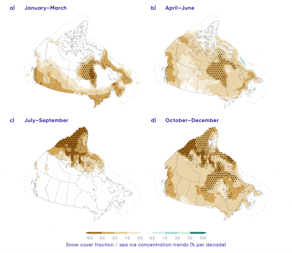
5.7

Discussion

This assessment of observed and projected changes to the Canadian cryosphere shows that the proportion of Canadian land and marine areas covered by seasonal snow, lake and river ice, and sea ice are decreasing over time; glaciers and ice caps are losing area and mass; and permafrost is warming and thawing. Further changes to the cryosphere are inevitable over the coming decades, driven by increasing air temperature. These changes will have major impacts on terrestrial, aquatic, and marine ecosystems, and on many sectors of the Canadian economy. Impacts will include risks to freshwater supply, from changes in peak pre-melt snow mass and the timing of snow melt across the country (Sturm et al., 2017172; Fyfe et al., 201750) and from loss of glaciers in the Coastal Mountains and western Rockies. More precipitation falling as rain rather than snow, combined with earlier spring thaw, will result in earlier peak streamflows, with subsequent reduced summer and autumn flows. Determining the likely timing of summer sea ice–free conditions for Canadian regions (Laliberté et al., 201697) has important implications for marine shipping in the Arctic (Pizzolato et al., 2016134). Lake and river ice conditions are important for overland transportation in the sub-Arctic and Arctic, both for goods transported via ice roads (Sturm et al., 2016171; Furgal and Prowse, 200849) and for local access to the land (Tremblay et al., 2008184). Thawing permafrost can release greenhouse gases (Olefeldt et al., 2016126) and contaminants (Schuster et al., 2018149), while permafrost degradation has effects on northern infrastructure, further adding to the high cost of northern development (AMAP, 2017b6; Pendakur, 2017129; Prowse et al., 2009136).

There is a strong reliance on satellite remote sensing to provide spatially continuous and long time series of cryosphere data for climate analysis. While these data are subject to limitations, there would be essentially no monitoring capability for Canadian snow and ice (especially in the Arctic) without satellite data. Models are another important source of information, albeit limited by uncertainties in both model performance and the data used to drive the models. Glacier mass balance and permafrost changes are determined from observed measurements from a limited number of locations. While the individual measurements are high-quality, spatial coverage and representativeness is poor. Some variables are difficult to monitor at all. For example, alpine snow poses a unique challenge because the coarse resolution of snow mass data from satellites and global models and the sparse networks of surface observations do not capture land cover variability and steep topographic gradients in areas of complex terrain. Addressing these methodological challenges and information gaps, potentially through the use of regional climate model simulations (Wrzesien et al., 2018196) is important because alpine regions are extremely sensitive to climate change and have a large impact on water resources (Fyfe et al., 201750; Berg and Hall, 201717; Sospedra-Alfonso et al., 2015167). A second example is sea ice thickness in the Canadian Arctic, where surface observations are few and current satellite data are unable to provide estimates within the narrow channels and waterways of the CAA. Snow depth on sea ice influences how thick ice can grow, but measurements are currently limited to airborne surveys, with limited sampling over time periods and geographic areas.

Detection and attribution studies show that climate change induced by human activity has driven observed changes to the cryosphere. This includes the decline in Northern Hemisphere spring snow cover (Najafi et al., 2016120), summer Arctic sea ice loss (Min et al., 2008111; Kirchmeier-Young et al., 201782), and declines in land ice mass balance (Marzeion et al., 2014107).

Projected changes to the cryosphere are closely tied to the amount of future warming (Thackeray et al., 2016179; Mudryk et al., 2017115; Notz and Stroeve, 2016125). While continued temperature increases are very likely, there will be natural variability at the decadal scale. This suggests that the influence of natural climate variability on air temperature trends will modulate the response of components of the cryosphere across different regions of Canada over the coming decades. Regardless of this decadal-scale natural variability, the two key messages from this integrated assessment of historical observations and future climate model projections of the Canadian cryosphere are clear. The proportion of Canadian land and marine areas covered by snow and ice have decreased, and permafrost temperatures are rising. These observed changes to the cryosphere are virtually certain to continue over the coming century in response to long-term increases in surface air temperatures under all emission scenarios.

Footnotes

  1. This report uses the same calibrated uncertainty language as in the IPCC’s Fifth Assessment Report. The following five terms are used to express assessed levels of confidence in findings based on the availability, quality and level of agreement of the evidence: very low, low, medium, high, very high. The following terms are used to express assessed likelihoods of results: virtually certain (99%–100% probability), extremely likely (95%–100% probability), very likely (90%–100% probability), likely (66%–100% probability), about as likely as not (33%–66% probability), unlikely (0%–33% probability), very unlikely (0%–10% probability), extremely unlikely (0%–5% probability), exceptionally unlikely (0%–1% probability). These terms are typeset in italics in the text. See chapter 1 for additional explanation.

References

  1. Abdalati, W., Krabill, W., Frederick, E., Manizade, S., Martin, C., Sonntag, J., Swift, R., Thomas, R., Yungel, J. and Koerner, R. (2004): Elevation changes of ice caps in the Canadian Arctic Archipelago; Journal of Geophysical Research, v. 109. doi:10.1029/2003JF000045
  2. Agnew, T. and Howell, S. (2003): The use of operational ice charts for evaluating passive microwave ice concentration data; Atmosphere-Ocean, v. 41, p. 317–331. doi:10.3137/ao.410405
  3. Alexeev, V., Arp, C., Jones, B. and Cai, L. (2016): Arctic sea ice decline contributes to thinning lake ice trend in northern Alaska; Environmental Research Letters, v. 11. doi:10.1088/1748-9326/11/7/074022
  4. Allard, M., Sarrazin, D. and L’Hérault, E. (2016): Températures du sol dans des forages et près de la surface dans le nord-est du Canada, v. 1.4 (1988-2016); Nordicana D8. doi:10.5885/45291SL-34F28A9491014AFD
  5. AMAP [Arctic Monitoring and Assessment Programme] (2017a): Snow, Water, Ice and Permafrost in the Arctic (SWIPA) 2017; Arctic Monitoring and Assessment Programme (AMAP), Oslo, Norway; xiv + 269 p.
  6. AMAP [Arctic Monitoring and Assessment Programme] (2017b): Adaptation Actions for a Changing Arctic: Perspectives from the Bering-Chukchi-Beaufort Region; Arctic Monitoring and Assessment Programme (AMAP), Oslo, Norway; xiv + 255 p.
  7. Arp, C., Jones, B., Lu, Z. and Whitman, M. (2012): Shifting balance of thermokarst lake ice regimes across the Arctic Coastal Plain of northern Alaska; Geophysical Research Letters, v. 39, p. 1–5. doi:1029/2012GL052518
  8. Babb, D., Galley, R., Barber, D. and Rysgaard, S. (2016): Physical processes contributing to an ice free Beaufort Sea during September 2012; Journal of Geophysical Research, v. 121, p. 267–283. doi:1002/2015JC010756
  9. Bai, X., Wang, J., Austin, J., Schwab, D., Assel, R., Clites, A., Bratton, J., Colton, M., Lenters, J., Lofgren, B. Wohlleben, T., Helfrich, S., Vanderploeg, H., Luo, I. and Leshkevich, G. (2015): A record-breaking low ice cover over the Great Lakes during winter 2011/2012: Combined effects of a strong positive NAO and La Nina; Climate Dynamics, v. 44, p. 1187-1213. doi:10.1007/s00382-014-2225-2
  10. Barber, D.G., Meier, W.N., Gerland, S., Mundy, C.J., Holland, M., Kern, S., Li, Z., Michel, C., Perovich, D.K., Tamura, T., Berge, J., Bowman, J., Christiansen, J.S., Ehn, J.K., Ferguson, S., Granskog, M.A., Kikuchi, T., Kuosa, H., Light, B., Lundholm, N., Melnikov, I.A., Polashenski, C., Smedsrud, L.H., Spreen, G., Tschudi, M., Vihma, T., Webster, M. and Zhang, L. (2017): Arctic Sea Ice; in Snow Water Ice and Permafrost in the Arctic (SWIPA) 2017 Assessment, Arctic Monitoring and Assessment Programme, Oslo, Norway, 103–136.
  11. Barrand, N. and Sharp, M. (2010): Sustained rapid shrinkage of Yukon glaciers since the 1957/58 International Geophysical Year; Geophysical Research Letters, v. 37. doi:10.1029/2009GL042030
  12. Barrand, N., Way, R., Bell, T. and Sharp, M. (2017): Recent changes in area and thickness of Torngat Mountain glaciers (northern Labrador, Canada); The Cryosphere, v. 11, p. 157–168. doi:10.5194/tc-11-157-2017
  13. Bash, E. and Marshall, S. (2014): Estimation of glacial melt contributions to the Bow River, Alberta, Canada, using a radiation-temperature melt model; Annals of Glaciology, v. 55, issue 66, p. 138–152. doi:10.3189/2014AoG66A226
  14. Beck, I., Ludwig, R., Bernier, M., Levesque, E. and Boike, J. (2015): Assessing permafrost degradation and land cover changes (1986–2009) using remote sensing data over Umiujaq, sub-Arctic Québec; Permafrost and Periglacial Processes, v. 26, p. 129– doi:10.1002/ppp.1839
  15. Beedle, M., Menounos, B. and Wheate, R. (2015): Glacier change in the Cariboo Mountains, British Columbia, Canada (1952–2005); The Cryosphere, v. 9, p. 65–80. doi:10.5194/tc-9-65-2015
  16. Beltaos, S. and Prowse, T. (2009): River-ice hydrology in a shrinking cryosphere; Hydrological Processes, v. 23, p. 122– doi:10.1002/hyp.7165
  17. Berg, N. and Hall, A. (2017): Anthropogenic warming impacts on California snowpack during drought; Geophysical Research Letters, v. 44, p. 2511–2518. doi:10.1002/2016GL072104
  18. Berthier, E., Vincent, C., Magnússon, E., Gunnlaugsson, Á., Pitte, P., Le Meur, E., Masiokas, M., Ruiz, L., Pálsson, F., Belart, J. and Wagnon, P. (2014): Glacier topography and elevation changes derived from Pléiades sub-meter stereo images; The Cryosphere, v. 8, p. 2275– doi: 10.5194/tc-8-2275-2014
  19. Bouchard, F., Francus, P., Pientz, , Laurion, I. and Feyte, S. (2014): Subarctic thermokarst ponds: Investigating recent landscape evolution and sediment dynamics in thawed permafrost of northern Québec (Canada); Arctic, Antarctic, and Alpine Research, v. 46, p. 251–271. doi: 10.1657/1938-4246-46.1.251
  20. Brown, R. and Braaten, R. (1998): Spatial and temporal variability of Canadian monthly snow depths, 1946–1995; Atmosphere-Ocean, v. 36, p. 37– doi:10.1080/07055900.1998.9649605
  21. Brown, R. and Cote, P. (1992): Interannual variability of landfast ice thickness in the Canadian high Arctic, 1950–89; Arctic, v. 45, p. 273–284.
  22. Brown, L. and Duguay, C. (2010): The response and role of ice cover in lake-climate interactions; Progress in Physical Geography, v. 34. doi:10.1177/0309133310375653
  23. Brown, L. and Duguay, C. (2011): The fate of lake ice in the North American Arctic; The Cryosphere, v. 5, p. 869–892. doi:10.5194/tc-5-869-2011
  24. Brown, R. and Mote, P. (2009): The response of Northern Hemisphere snow cover to a changing climate; Journal of Climate, v. 22, p. 2124-2145. doi:10.1175/2008JCLI2665.1
  25. Brown, R., Barrette, C., Brown, L., Chaumont, D., Grenier, P., Howell, S. and Sharp, M. (2018): Climate variability, trends and projected change; in From Science to Policy in the Eastern Canadian Arctic: An Integrated Regional Impact Study (IRIS) of Climate Change and Modernization, (ed.) Bell, T., and Brown, T.M.; ArcticNet, Quebec City, Quebec, p. 57–
  26. Brown, R., Schuler, D., Bulygina, O., Derksen, C., Luojus, K., Mudryk, L., Wang, L. and Yang, D. (2017): Arctic terrestrial snow; in Snow Water Ice and Permafrost in the Arctic (SWIPA) 2017 Assessment, Arctic Monitoring and Assessment Programme, Oslo, Norway, p. 40.
  27. Brutel-Vuilmet, C., Ménégoz, M. and Krinner, G. (2013): An analysis of present and future seasonal Northern Hemisphere land snow cover simulated by CMIP5 coupled climate models; The Cryosphere, v. 7, p. 67–80. doi:10.5194/tc-7-67-2013
  28. Burgess, D. (2017): Mass balance of ice caps in the Queen Elizabeth Islands: 2014–2015; Geological Survey of Canada, Open File 8223, p. 36. doi:10.4095/300231
  29. Bush, E., Loder, J., James, T., Mortsch, L. and Cohen, S. (2014): An Overview of Canada’s Changing Climate; in Canada in a Changing Climate: Sector Perspectives on Impacts and Adaptation, (ed.) F.J. Warren and D.S. Lemmen; Government of Canada, Ottawa, Ontario, 23–64.
  30. Canadian Ice Service (2007): Regional Charts: History, Accuracy, and Caveats, CIS Archive Documentation Series No. 1, Ottawa, Ontario.
  31. Chadburn, S., Burke, E., Cox, P., Friedlingstein, P., Hugelius, G. and Westermann, S. (2017): An observation-based constraint on permafrost loss as a function of global warming; Nature Climate Change, v. 7, p. 40– doi:10.1038/NCLIMATE3262
  32. Clarke, G., Jarosch, A., Anslow, F., Radić, V., & Menounos, B. (2015): Projected deglaciation of western Canada in the in the 21st century; Nature Geoscience, v. 8, p. 372–377. doi:10.1038/NGEO2407
  33. Comiso, J. (2012): Large decadal decline of the Arctic multiyear ice cover; Journal of Climate, v. 25, p. 1176–1193. doi:10.1175/JCLI-D-1100113.1
  34. Cooley, S. and Pavelsky, T. (2016): Spatial and temporal patterns in Arctic river ice breakup revealed by automated ice detection from MODIS imagery; Remote Sensing of Environment, v. 175, p. 310–322. doi:10.1016/j.rse.2016.01.004
  35. Dawson, J., Pizzolato, L., Howell, S., Copland L. and Johnston, M. (2018): Temporal and spatial patterns of ship traffic in the Canadian Arctic from 1990 to 2015; Arctic, v. 71, issue 7, p. 15– doi:10.14430/arctic4698
  36. Derksen, C., and Brown, R. (2012): Spring snow cover extent reductions in the 2008–2012 period exceeding climate model projections; Geophysical Research Letters, v. 39. doi:10.1029/2012GL053387
  37. Derksen, C., Brown, R., Mudryk, L. and Luojus, K. (2016): Terrestrial Snow (Arctic). In State of the Climate in 2015; Bulletin of the American Meteorological Society, v. 97, S145–
  38. Derksen, C., Smith, S., Sharp, M., Brown, L., Howell, S., Copland, L., Mueller, D., Gauthier, Y., Fletcher, C., Tivy, A., Bernier, M., Bourgeois J., Brown, R., Burn, C., Duguay, C., Kushner, P., Langlois, A., Lewkowicz, A., Royer, A. and Walker, A. (2012): Variability and change in the Canadian Cryosphere; Climatic Change, v. 115, p. 59–88. doi:10.1007/s10584-012-0470-0
  39. Deser, C., and Teng, H. (2008): Evolution of Arctic sea ice concentration trends and the role of atmospheric circulation forcing, 1979–2007; Geophysical Research Letters, v. 35. doi:10.1029/2007GL032023
  40. Dibike, Y., Prowse, T., Bonsal, B., de Rham, L. and Saloranta, T. (2012): Simulation of North American lake-ice cover characteristics under contemporary and future climate conditions; International Journal of Climatology, v. 32, p. 695–709. doi:10.1002/joc.2300
  41. Du, J., Kimball, J., Duguay, C., Kim, Y. and Watts, J. (2017): Satellite microwave assessment of Northern Hemisphere lake ice phenology from 2002 to 2015; The Cryosphere, v. 11, p. 47–63. doi:10.5194/tc-11-47-2017
  42. Duchesne, C., Smith, S., Ednie, M. and Bonnaventure, P. (2015): Active layer variability and change in the Mackenzie Valley, Northwest Territories; in GEOQuébec 2015, Proceedings, 68th Canadian Geotechnical Conference and 7th Canadian Conference on Permafrost, Québec, Quebec.
  43. Duguay, M. (2013): Permafrost changes along the Alaska Highway Corridor, Southern Yukon, from ground temperature measurements and DC electrical resistivity tomography; MSc Thesis, University of Ottawa, Ottawa, Ontario. doi:10.20381/ruor-3084
  44. Duguay, C., Flato, G., Jeffries, M., Menard, P., Morris, K. and Rouse, W. (2003): Ice-cover variability on shallow lakes at high latitudes: Model simulations and observations; Hydrological Processes, v. 17, p. 3465–3483. doi:10.1002/hyp.1394
  45. Duguay, C., Prowse, T., Bonsal, B., Brown, R. Lacroix, M. and Ménard, P. (2006): Recent trends in Canadian lake ice cover; Hydrological Processes, v. 20, p. 781-801. doi:10.1002/hyp.6131
  46. Ednie, M. and Smith, S. (2015): Permafrost temperature data 2008–2014 from community-based monitoring sites in Nunavut; Geological Survey of Canada, Open File 7784. doi:10.4095/296705
  47. Fisher, J., Estop-Aragones, C., Thierry, A., Charman, D., Wolfe S., Hartley I., Murton, J., Williams, M. and Phoenix, G. (2016): The influence of vegetation and soil characteristics on active-layer thickness of permafrost soils in boreal forest; Global Change Biology, v. 22, p. 3127– doi:10.1111/gcb.13248
  48. Ford, J., Bell, T. and Couture, N. (2016): Perspectives on Canada’s North Coast region; in Canada’s Marine Coasts in a Changing Climate, (ed.) Lemmen, D.S, Warren, F.J., James, T.S. and Mercer Clarke, C.S.L.; Government of Canada, Ottawa, Ontario, p. 153–
  49. Furgal, C. and Prowse, T. (2008): Northern Canada; in From impacts to adaptation: Canada in a changing climate 2007, (ed.) Lemmen, D.S., Warren, F.J., Lacroix, J., Bush, E.; Government of Canada, Ottawa, Ontario, p. 57–118.
  50. Fyfe, J., Derksen, C., Mudryk, L., Flato, G., Santer, B., Swart, N., Molotch, N., Zhang, X., Wan, H., Arora, V., Scinocca, J. and Jiao, Y. (2017): Large near-term projected snowpack loss over the western United States; Nature Communications, v. 8. doi:10.1038/NCOMMS14996
  51. Fyfe, J.C., von Salzen, K., Gillett, N.P., Aurora, V.K., Flato, G.F and McConnell, J.R. (2013): One hundred years of Arctic surface temperature variation due to anthropogenic influence. Scientific Reports, v. 3, article no. 2645. doi:10.1038/srep02645.
  52. Galley, R., Babb, D., Ogi, M., Else, B., Geilfus, N.-X., Crabeck, O., Barber, D. and Rysgaard, S. (2016): Replacement of multiyear sea ice and changes in the open water season duration in the Beaufort Sea since 2004; Journal of Geophysical Research, v. 121, p. 1806–1823. doi:10.1002/2015JC011583
  53. Gardner, A., Moholdt, G., Cogley, J., Wouters, B., Arendt, A., Wahr, J., Berthier, E., Hock, R., Pfeffer, W., Kaser, G., Ligtenberg, S., Bolch, T., Sharp, M., Hagen, J., Van Den Broeke, M. and Paul, F. (2013): A reconciled estimate of glacier contributions to sea level rise: 2003 to 2009; Science, v. 340, p. 852– doi:10.1126/science.1234532
  54. Gardner, A., Moholdt, G., Wouters, B., Wolken, G., Burgess, D., Sharp, M., Cogley, G., Braun, C. and Labine, C. (2011): Sharply increased mass loss from glaciers and ice caps in the Canadian Arctic Archipelago. Nature, v. 473, p. 357– doi:10.1038/nature10089
  55. Gilbert, A., Flowers, G., Miller, G., Rabus, B., van Wychen, W., Gardner, A. and Copland, L. (2016): Sensitivity of Barnes Ice Cap, Baffin Island, Canada, to climate state and internal dynamics; Journal of Geophysical Research, v. 121, p. 1516–1539. doi:10.1002/2016JF003839
  56. Gillett, N., Stone, D., Stott, P., Nozawa, T., Karpechko, A., Hegerl, G., Wehner, M. and Jones, P. (2008): Attribution of polar warming to human influence; Nature Geoscience, v. 1, p. 750– doi:10.1038/ngeo338
  57. Godin, E., Fortier, D. and Levesque, E. (2016): Nonlinear thermal and moisture response of ice-wedge polygons to permafrost disturbance increases heterogeneity of high Arctic wetland; Biogeosciences, v. 13, p. 1439– doi:10.5194/bg-13-1439-2016
  58. Gray, J., Davense, G., Fortier D. and Godin, E. (2017): The thermal regime of mountain permafrost at the summit of Mont Jacques-Cartier in the Gaspé Peninsula, Québec, Canada: A 37 year record of fluctuations showing an overall warming trend; Permafrost and Periglacial Processes, v. 28, p. 266– doi:10.1002/ppp.1903
  59. Gray, L., Burgess, D., Copland, L., Dunse, T., Langley, K. and Schuler, T. (2015): Cryosat delivers monthly and inter-annual surface elevation change for Arctic ice caps; The Cryosphere, v. 9, p. 1895– doi:10.5194/tc-9-1895-2015
  60. Gray, L., Short, N., Mattar, K. and Jezek, K. (2001): Velocities and flux of the Filchner Ice Shelf and its tributaries determined from speckle tracking interferometry; Canadian Journal of Remote Sensing, v. 27, p. 193–206. doi:10.1080/07038992.2001.10854936
  61. Greene, S., Walter Anthony, K., Archer, D., Sepulveda-Jauregui, A. and Martinez-Cruz, K. (2014): Modeling the impediment of methane ebullition bubbles by seasonal lake ice; Biogeosciences, v. 11, p. 6791–6811. doi:10.5194/bg-11-6791-2014
  62. Griffiths, K., Michelutti. N., Sugar, M., Douglas M. and Smol, J. (2017): Ice-cover is the principal driver of ecological change in High Arctic lakes and ponds; PLoS ONE, v. 12. doi:10.1371/journal.pone.0172989
  63. Gula, J. and Peltier, W. (2012): Dynamical downscaling over the Great Lakes basin of North America using the WRF regional climate model: the impact of the Great Lakes system on regional greenhouse warming; Journal of Climate, v. 25, p. 7723– doi:10.1175/JCLI-D-00388.1
  64. Guo, D. and Wang, H. (2016): CMIP5 permafrost degradation projection: A comparison among different regions; Journal of Geophysical Research, v. 121, p. 4499–4517. doi:10.1002/2015JD024108
  65. Haas, C. and Howell, S. (2015): Ice thickness in the Northwest Passage; Geophysical Research Letters, v. 42, p. 7673–7680. doi:10.1002/2015GL065704
  66. Haas, C., Hendricks, S., Eicken, H. and Herber, A. (2010): Synoptic airborne thickness surveys reveal state of Arctic sea ice cover; Geophysical Research Letters, v. 37, issue 9. doi:10.1029/2010GL042652
  67. Harig, C. and Simons, F. (2016): Ice mass loss in Greenland, the Gulf of Alaska, and the Canadian Archipelago: Seasonal cycles and decadal trends; Geophysical Research Letters, v. 43. doi:10.1002/2016GL067759
  68. Hernández-Henríquez, M., Déry, S. and Derksen, C. (2015): Polar amplification and elevation-dependence in trends of Northern Hemisphere snow cover extent, 1971–2014; Environmental Research Letters, v. 10. doi:10.1088/1748-9326/10/4/044010
  69. Hochheim, K. and Barber, D. (2014): An update on the ice climatology of the Hudson Bay system; Arctic Antarctic and Alpine Research, v. 46, p. 66–83. doi:10.1657/1938-4246-46.1.66
  70. Howell, S., Brady, M., Derksen, C. and Kelly, R. (2016a): Recent changes in sea ice area flux through the Beaufort Sea during the summer; Journal of Geophysical Research, v. 121, p. 2659–2672. doi:10.1002/2015JC011464
  71. Howell, S., Brown, L., Kang, K. and Duguay, C. (2009): Variability in ice phenology on Great Bear Lake and Great Slave Lake, Northwest Territories Canada, from SeaWinds/QuikSCAT: 2000–2006; Remote Sensing of Environment, v. 113, p. 813–834. doi:10.1016/j.rse.208.12.007
  72. Howell, S., Derksen, C., Pizzolato, L. and Brady, M. (2015): Multiyear ice replenishment in the Canadian Arctic Archipelago: 1997–2013; Journal of Geophysical Research, v. 120, p. 1623–1637. doi:10.1002/2015JC010696
  73. Howell, S., Duguay, C. and Markus, T. (2009a): Sea ice conditions and melt season duration variability within the Canadian Arctic Archipelago: 1979–2008; Geophysical Research Letters, v. 36. doi:10.1029/2009GL037681
  74. Howell, S., Laliberté, F., Kwok, R., Derksen, C. and King, J. (2016b): Landfast ice thickness in the Canadian Arctic Archipelago from Observations and Models; The Cryosphere, v. 10. doi:10.5194/tc-10-1463-2016
  75. Howell, S., Wohlleben, T., Komarov, A., Pizzolato, L. and Derksen, C. (2013): Recent extreme light years in the Canadian Arctic Archipelago: 2011 and 2012 eclipse 1998 and 2007; The Cryosphere, v. 7, p. 1753– doi:10.5194/tc-7-1753-2013
  76. Hugelius, G., Strauss, J., Zubrzycki, S., Harden, J., Schuur, E., Ping, C-L., Schirrmeister, L., Grosse, G., Michaelson, G., Koven, C., O’Donnell, J., Elberling, B., Mishra, U., Camill, P., Yu, Z., Palmtag, J. and Kuhry, P. (2014): Estimated stocks of circumpolar permafrost carbon with quantified uncertainty ranges and identified data gaps; Biogeosciences, v. 11, p. 6573–6593. doi:10.5194/bg-11-6573-2014
  77. Jacob, T., Wahr, J., Pfeffer, W. and Swenson, W. (2012): Recent contributions of glaciers and ice caps to sea level rise; Nature, v. 482, p. 514– doi:10.1038/nature10847
  78. Jahn, A. (2018): Reduced probability of ice-free summers for 1.5 °C compared to 2 °C warming; Nature Climate Change, v. 8, p. 409–413. doi:10.1038/s41558-018-0127-8
  79. James, M., Lewkowicz, A., Smith, S. and Miceli, C. (2013): Multi-decadal degradation and persistence of permafrost in the Alaska Highway corridor, northwest Canada; Environmental Research Letters, v. 8. doi:10.1088/1748-9326/8/4/045013
  80. Jolivel, M. and Allard, M. (2017): Impact of permafrost thaw on the turbidity regime of a subarctic river: the Sheldrake River, Nunavik, Quebec; Arctic Science, v. 3. p. 451– doi:10.1139/as-2016-0006
  81. Jost, G., Moore, R., Menounos, B. and Wheate, R. (2012): Quantifying the contribution of glacier runoff to streamflow in the upper Columbia River Basin, Canada; Hydrology and Earth System Sciences, v. 16, p. 849–860. doi:10.5194/hess-16-849-2012
  82. Kirchmeier-Young, M., Zwiers, F. and Gillett, N. (2017): Attribution of extreme events in Arctic sea ice extent; Journal of Climate, v. 30, p. 553-571. doi:1175/JCLI-D-16-0412.1
  83. Koch, J., Clague, J. and Osborn, G. (2014): Alpine glaciers and permanent ice and snow patches in western Canada approach their smallest sizes since the mid-Holocene, consistent with global trends; The Holocene, v. 24, p. 1639– doi:10.1177%2F0959683614551214
  84. Koch, J., Menounos, B. and Clague, J. (2009): Glacier change in Garibaldi Provincial Park, southern Coast Mountains, British Columbia, since the Little Ice Age; Global and Planetary Change, v. 66, p. 161– doi:10.1016/j.gloplacha.2008.11.006
  85. Koerner, R.M. (2005): Mass balance of glaciers in the Queen Elizabeth Islands, Nunavut, Canada; Annals of Glaciology, v. 42, p. 417– doi:10.3189/172756405781813122
  86. Kokelj, S. and Jorgenson, M. (2013): Advances in thermokarst research; Permafrost and Periglacial Processes, v. 24, p. 108– doi:10.1002/ppp.1779
  87. Kokelj, S., Lacelle, D., Lantz, T., Tunnicliffe, J., Malone, L., Clark, I. and Chin, K. (2013): Thawing of massive ground ice in mega slumps drives increases in stream sediment and solute flux across a range of watershed scales; Journal of Geophysical Research, v. 118, p. 681– doi:10.1002/jgrf.20063
  88. Kokelj, S., Lantz, T., Tunnicliffe, J., Segal, R. and Lacelle, D. (2017a): Climate-driven thaw of permafrost preserved glacial landscapes, northwestern Canada; Geology, v. 45, p. 371– doi:10.1130/G38626.1
  89. Kokelj, S., Palmer, M., Lantz, T. and Burn, C. (2017b): Ground temperatures and permafrost warming from forest to tundra, Tuktoyaktuk Coastlands and Anderson Plain, NWT, Canada; Permafrost and Periglacial Processes, v. 28, p. 543– doi:10.1002/ppp.1934
  90. Kokelj, S., Tunnicliffe, J., Lacelle, D., Lantz, T., Chin, K. and Fraser, R. (2015): Increased precipitation drives mega slump development and destabilization of ice-rich permafrost terrain, northwestern Canada; Global and Planetary Change, v. 129, p. 56–68. doi:10.1016/j.gloplacha.2015.02.008
  91. Koven, C., Riley, W. and Stern, A. (2013): Analysis of permafrost thermal dynamics and response to climate change in the CMIP5 Earth system models; Journal of Climate, v. 26, p. 1877–1900. doi:10.1175/JCLI-D-12-00228.1
  92. Krabill, W., Frederick, E., Manizade, S., Martin, C., Sonntag, J., Swift, R. Thomas, R., Wright, W., Yungel, J. and Abdalati, W. (2002): Aircraft laser altimetry measurements of changes of the Greenland ice sheet: Technique and accuracy assessment; Journal of Geodynamics, v. 34, p. 357– 376. doi:10.1016/S0264-3707(02)00040-6
  93. Krishfield, R., Proshutinsky, A., Tateyama, K., Williams, W., Carmack, E., McLaughlin, F. and Timmermans, M.-L. (2014): Deterioration of perennial sea ice in the Beaufort Gyre from 2003 to 2012 and its impact on the oceanic freshwater cycle; Journal of Geophysical Research, v. 119, p. 1271–1305. doi:10.1002/2013JC008999
  94. Kwok, R. and Cunningham, G. (2010): Contribution of melt in the Beaufort Sea to the decline in Arctic multiyear sea ice coverage: 1993–2009; Geophysical Research Letters, v. 37. doi:10.1029/2010GL044678
  95. Kwok, R. and Cunningham, G. (2015): Variability of Arctic sea ice thickness and volume from CryoSat-2; Philosophical Transactions of the Royal Society A, v. 373. doi:10.1098/rsta.2014.0157
  96. Kwok, R. and Rothrock, D. (2009): Decline in Arctic sea ice thickness from submarine and ICESat records: 1958–2008; Geophysical Research Letters, v. 36. doi:10.1029/2009GL039035
  97. Laliberté, F., Howell, S., and Kushner, P. (2016): Regional variability of a projected sea ice–free Arctic during the summer months; Geophysical Research Letters, v. 43. doi:10.1002/2015GL066855
  98. Lamoureux, S., Forbes, D., Bell, T. and Manson, G. (2015): The impact of climate change on infrastructure in the western and central Canadian Arctic; in From Science to Policy in the Western and Central Canadian Arctic: An Integrated Regional Impact Study (IRIS) of climate change and modernization, (ed.) Stern, G.A., and Gaden, A.; ArcticNet, Quebec, p. 301–
  99. Lantuit, H. and Pollard, W. (2008): Fifty years of coastal erosion and retrogressive thaw slump activity on Herschel Island, southern Beaufort Sea, Yukon Territory, Canada; Geomorphology, v. 95, p. 84– doi:10.1016/j.geomorph.2006.07.040
  100. Lantz, T. and Turner, K. (2015): Changes in lake area in response to thermokarst processes and climate in Old Crow Flats, Yukon; Journal of Geophysical Research, v. 120, p. 513– doi:10.1002/2014JG002744
  101. Lantz, T., Marsh, P. and Kokelj, S. (2013): Recent shrub proliferation in the Mackenzie Delta uplands and microclimatic implications; Ecosystems, v. 16, p. 47– doi:10.1007/s10021-012-9595-2
  102. Laxon, S., Giles, K., Ridout, A., Wingham, D., Willatt, R., Cullen, R., Kwok, R., Schweiger, A., Zhang, J., Haas, C., Hendricks, S., Krishfield, R., Kurtz, N., Farrell, S. and Davidson, M. (2013): CryoSat-2 estimates of Arctic sea ice thickness and volume; Geophysical Research Letters, v. 40, p. 732–737. doi:10.1002/grl.50193
  103. Lenaerts, J., van Angelen, J., van den Broeke, M., Gardner, A., Wouters, B. and van Meijgaard, E. (2013): Irreversible mass loss of Canadian Arctic Archipelago glaciers; Geophysical Research Letters, v. 40, p. 870–874. doi:10.1002/grl.50214
  104. Loder, J., van der Baaren, A. and Yashayaev, I. (2015): Climate comparisons and change projections for the Northwest Atlantic from six CMIP5 models; Atmosphere-Ocean, v. 53, p. 529– doi:10.1080/07055900.2015.1087836
  105. Mamet, S., Chun, K., Kershaw, G., Loranty, M. and Kershaw, G. (2017): Recent increases in permafrost thaw rates and areal loss of palsas in the western Northwest Territories, Canada; Permafrost and Periglacial Processes, v. 28, p. 619– doi:10.1002/ppp.1951
  106. Mankin, J. and Diffenbaugh, N. (2014): Influence of temperature and precipitation variability on near-term snow trends; Climate Dynamics, v. 45, p. 1099– doi:10.1007/s00382-014-2357-4
  107. Marzeion, B., Cogley, J. G., Richter, K. and Parkes, D. (2014): Attribution of global glacier mass loss to anthropogenic and natural causes; Science, v. 345, p. 919– doi:10.1126/science.1254702
  108. Marzeion, B., Jarosch, A., and Hofer, M. (2012): Past and future sea-level change from the surface mass balance of glaciers; The Cryosphere, v. 6, p. 1295– doi:10.5194/tc-6-1295-2012
  109. Maslanik, J., Stroeve, J., Fowler, C. and Emery, W. (2011): Distribution and trends in Arctic sea ice age through spring 2011; Geophysical Research Letters, v. 38. doi:10.1029/2011GL047735
  110. Mason, L., Riseng, C., Gronewold, A., Rutherford, E., Wang, J., Clites, A., Smith, S. and McIntyre, P. (2016): Fine-scale spatial variation in ice cover and surface temperature trends across the surface of the Laurentian Great Lakes; Climatic Change, v. 138, p. 71–83. doi:10.1007/s10584-016-1721-2
  111. Min, S.-K., Zhang, X., Zwiers, F. and Agnew, T. (2008): Human influence on Arctic sea ice detectable from early 1990s onwards; Geophysical Research Letters, v. 35. doi:10.1029/2008GL035725
  112. Mortimer, C., Sharp, M. and Wouters, B. (2016): Glacier surface temperatures in the Canadian High Arctic, 2000–15; Journal of Glaciology, v. 62, p. 963–975. doi:10.1017/jog.2016.80
  113. Mudryk, L., Derksen, C., Howell, S., Laliberté, F., Thackeray, C., Sospedra-Alfonso, R., Vionnet, V., Kushner, P. and Brown, R. (2018): Canadian snow and sea ice: historical trends and projections; The Cryosphere, v. 12, p. 1157– doi:10.5194/tc-12-1157-2018
  114. Mudryk, L., Derksen, C., Kushner, P. and Brown, R. (2015): Characterization of Northern Hemisphere snow water equivalent datasets, 1981–2010; Journal of Climate, v. 28, p. 8037– doi:10.1175/JCLI-D-15-0229.1
  115. Mudryk, L., Kushner, P., Derksen, C. and Thackeray, C. (2017): Snow cover response to temperature in observational and climate model ensembles; Geophysical Research Letters, v. 44. doi:10.1002/2016GL071789
  116. Mueller, D., Copland, L. and Jeffries, M. (2017): Changes in Canadian Arctic ice shelf extent since 1906; in Arctic Ice Shelves and Ice Islands, (ed.) L. Copland and D. Mueller, Springer-Verlag.
  117. Mueller, D., van Hove, P., Antoniades, D., Jeffries, M. and Vincent, W. (2009): High Arctic lakes as sentinel ecosystems: Cascading regime shifts in climate, ice cover, and mixing; Limnology and Oceanography, v. 54, p. 2371–2385. doi:10.4319/lo.2009.54.6_part_2.2371
  118. Mullan, D., Swindles, G., Patterson, T., Galloway, J., Macumber, A., Falck, H., Crossley, L., Chen, J. and Pisaric, M. (2017): Climate change and the long-term viability of the World’s busiest heavy haul ice road; Theoretical and Applied Climatology, v. 129, p. 1089–1108. doi:10.1007/s00704-016-1830-x
  119. Najafi, M., Zwiers, F. and Gillett, N. (2015): Attribution of Arctic temperature change to greenhouse-gas and aerosol influences; Nature Climate Change, v. 5, p. 246– doi:10.1038/nclimate2524
  120. Najafi, M., Zwiers, F. and Gillett, N. (2016): Attribution of the spring snow cover extent decline in the Northern Hemisphere, Eurasia and North America to anthropogenic influence; Climatic Change, v. 136, p. 571–586. doi:10.1007/s10584-016-1632-2
  121. NASEM [National Academies of Science, Engineering, and Medicine] (2016): Attribution of extreme weather events in the context of climate change; The National Academies Press, p. 186. doi:10.17226/21852
  122. Naz, B., Frans, C., Clarke, G., Burns, P. and Lettenmaier, D. (2014): Modeling the effect of glacier recession on streamflow response using a coupled glacio-hydrological model; Hydrology and Earth System Sciences, v. 18, p. 787–802. doi:10.5194/hess-18-787-2014
  123. Neumann, N., Smith, C., Derksen, C. and Goodison, B. (2006): Characterizing local scale snow cover using point measurements; Atmosphere-Ocean, v. 44 p. 257– doi:10.3137/ao.440304
  124. Noël, B., van de Berg, W., Lhermitte, S., Wouters, B., Schaffer, N. and van den Broeke, M. (2018): Six decades of glacial mass loss in the Canadian Arctic Archipelago; Journal of Geophysical Research, v. 123. doi:10.1029/2017JF004304
  125. Notz, D. and Stroeve, J. (2016): Observed Arctic sea-ice loss directly follows anthropogenic CO2 emission; Science, v. 354. doi:10.1126/science.aag2345
  126. Olefeldt, D., Goswami, S., Grosse, G., Hayes, D., Hugelius, G., Kuhry, P., McGuire, A., Romanovsky, V., Sannel, A., Schuur, E. and Turetsky, M. (2016): Circumpolar distribution and carbon storage of thermokarst landscapes; Nature Communications, v. 7, p. 1–11. doi:10.1038/ncomms13043
  127. Paquette, M., Fortier, D., Mueller, D., Sarrazin, D. and Vincent, W. (2015): Rapid disappearance of perennial ice on Canada’s most northern lake; Geophysical Research Letters, v. 42, p. 1433–1440. doi:10.1002/2014GL062960
  128. Parkinson, C. (2014): Spatially mapped reductions in the length of the Arctic sea ice season; Geophysical Research Letters, v. 41, p. 4316–4322. doi:10.1002/2014GL060434
  129. Pendakur, K. (2017): Northern Territories; in Climate risks and adaptation practices for the Canadian transportation sector 2016; (ed.) Palko, K. and Lemmen, D.S.; Government of Canada, Ottawa, Ontario, p. 27–
  130. Peng, G. and Meier, W. (2017): Temporal and regional variability of Arctic sea-ice coverage from satellite data; Annals of Glaciology, v. 59, p. 191– doi:10.1017/aog.2017.32
  131. Perrault, N., Levesque, E., Fortier, D., Gratton. and Lamarque, L. (2017): Remote sensing evaluation of High Arctic wetland depletion following permafrost disturbance by thermo-erosion gullying processes; Arctic Science, v. 3, p. 237–253. doi:10.1139/as-2016-0047
  132. Perrin, A., Dion, J., Eng, S., Sawyer, D., Nodleman, J., Comer, N., Auld, H., Sparling, E., Harris, M., Nodelman, J. and Kinnear, L. (2015): Economic implications of climate change adaptations for mine access roads in northern Canada. Northern Climate ExChange, Yukon Research Centre, Yukon College, p. 93.
  133. Peterson, I., Pettipas, R. and Rosing-Asvid, A. (2015): Trends and variability in sea ice and icebergs off the Canadian East Coast; Atmosphere-Ocean, v. 53, p. 582– doi:10.1080/07055900.2015.1057684
  134. Pizzolato, L., Howell, S., Dawson, J., Laliberté, F. and Copland, L. (2016): The influence of declining sea ice on shipping activity in the Canadian Arctic; Geophysical Research Letters, v. 43. doi:10.1002/2016GL071489
  135. Prowse, T. (2012): Lake and River ice in Canada; in Changing Cold Environments: A Canadian Perspective, 1st edition, (eds.) H. French, and O. Slaymaker, John Wiley & Sons, p. 163–181.
  136. Prowse, T., Furgal, C., Chouinard, R., Melling, H., Milburn, D. and Smith, S. (2009): Implications of climate change for economic development in Northern Canada: energy, resource, and transportation sectors; Ambio, v. 38, p. 272– doi:10.1479/0044-7447-38.5.272
  137. Prowse, T., Shrestha, R., Bonsal, B. and Dibike, Y. (2010): Changing spring air-temperature gradients along large northern rivers: Implications for severity of river-ice floods; Geophysical Research Letters, v. 37. doi:10.1029/2010GL044878
  138. Quinton, W., and Baltzer, J. (2013): The active-layer hydrology of a peat plateau with thawing permafrost (Scotty Creek, Canada); Hydrogeology Journal, v. 21, p. 201– doi: 10.1007/s10040-012-0935-2
  139. Radić, V., and Hock, R. (2011): Regionally differentiated contribution of mountain glaciers and ice caps to future sea-level rise; Nature Geoscience, v. 4, p. 91–94. doi:10.1038/ngeo1052
  140. Radić, V., Bliss, A., Beedlow, A., Hock, R., Miles, E. and Cogley, J.G. (2014): Regional and global projections of twenty-first century glacier mass changes in response to climate scenarios from global climate models; Climate Dynamics, v. 42, p. 37–58. doi:10.1007/s00382-013-1719-7
  141. Raisanen, J. (2008): Warmer climate: less or more snow?; Climate Dynamics, v. 30, p. 307-319. doi: 10.1007/s00382-007-0289-y
  142. Richter-Menge, J. and Farrell, S. (2013): Arctic sea ice conditions in spring 2009–2013 prior to melt; Geophysical Research Letters, v. 40, p. 5888–5893. doi:10.1002/2013GL058011
  143. Rigor, I., Wallace, J. and Colony, R. (2002): Response of sea ice to the Arctic oscillation; Journal of Climate, v. 15, p. 2648–2663. doi: 10.1175/1520-0442(2002)015%3C2648:ROSITT%3E2.0.CO;2
  144. Romanovsky, V., Isaksen, K., Drozdov, D., Anisimov, O., Instanes, A., Leibman, M., McGuire, A., Shiklomanov, N., Smith, S., and Walker, D. (2017a): Changing permafrost and its impacts; in Snow Water Ice and Permafrost in the Arctic (SWIPA) 2017; Assessment, Arctic Monitoring and Assessment Programme, Oslo, Norway, p. 65–
  145. Romanovsky, V., Smith, S. and Christiansen, H. (2010): Permafrost thermal state in the polar Northern Hemisphere during the International Polar Year 2007-2009: a synthesis; Permafrost and Periglacial Processes, v. 21, p. 106– doi:10.1002/ppp.689
  146. Romanovsky, V., Smith, S., Isaksen, K., Shiklomanov, N., Streletskiy, D., Kholodov, A. Christiansen, H., Drozdov, D., Malkova, G. and Marchenko, S. (2017b): Terrestrial Permafrost; in Arctic Report Card 2017, (ed.) J. Richter-Menge, J.E. Overland, J.T. Mathis, and E. Osborne <http://www.arctic.noaa.gov/Report-Card> [July 2018].
  147. Rouse, W., Oswald, C., Binyamin, J., Spence, C., Schertzer, W., Blanken, P., Bussieres, N. and Duguay, C. (2005): The role of northern lakes in a regional energy balance; Journal of Hydrometeorology, v. 6, p. 291–
  148. Rudy, A., Lamoureux, S., Kokelj, S., Smith, I. and England, J. (2017): Accelerating thermokarst transforms ice-cored terrain triggering a downstream cascade to the ocean; Geophysical Research Letters, v. 47. doi:10.1002/2017GL074912
  149. Schuster, P., Schaefer, K., Aiken, G., Antweiler,R., Dewild J., Gryziec, J., Gusmeroli, A., Hugelius, G., Jafarov, E., Krabbenhoft, D., Liu, L., Herman-Mercer, N., Mu, C., Roth, D., Schaefer, T., Striegl, R., Wickland, K. and Zhang, T. (2018): Permafrost stores a globally significant amount of mercury; Geophysical Research Letters, v. 45, p. 1463–1471. doi:10.1002/2017GL075571
  150. Segal, R., Lantz, T. and Kokelj, S. (2016): Acceleration of thaw slump activity in glaciated landscapes of the Western Canadian Arctic; Environmental Research Letters, v. 11. doi:10.1088/1748-9326/11/3/034025
  151. Serreze, M., Holland, M. and Stroeve, J. (2007): Perspectives on the Arctic’s shrinking sea ice cover; Science, v. 315, p. 1533–1536.
  152. Serreze, M., Raup, B., Braun, C., Hardy, D. and Bradley, R. (2017): Rapid wastage of the Hazen Plateau ice caps, northeastern Ellesmere Island, Nunavut, Canada; The Cryosphere, v. 11, p. 169–177. doi:10.5194/tc-11-169-2017
  153. Sharp, M., Burgess, D., Cawkwell, F., Copland, L., Davis, J., Dowdeswell, E., Dowdeswell, J., Gardner, A., Mair, D., Wang, L., Williamson, S., Wolken, G. and Wyatt, F. (2016): Remote sensing of recent glacier changes in the Canadian Arctic; in Global Land Ice Measurements from Space, (ed.) J. Kargel, G. Leonard, M. Bishop, A. Kääb, and B. Raup; Springer, p. 205– doi: 10.1007/978-3-540-79818-7doi
  154. Sharp, M., Burgess, D., Cogley, J. G., Ecclestone, M., Labine, C. and Wolken, G. (2011): Extreme melt on Canada’s Arctic ice caps in the 21st century; Geophysical Research Letters, v. 38, p. 3–7. doi:10.1029/2011GL047381
  155. Shepard, A., Ivins, E., Geruo, A., Barletta, V., Bentley, M., Bettadpur, S., Briggs, K., Bromwich, D., Forsberg, R., Galin, N., Horwath, M., Jacobs, S., Joughin, I., King, M., Lenaerts, J., Li, J., Ligtenberg, S., Luckman, A., Luthcke, S., McMillan, M., Meister, R., Milne, G., Mouginot, J., Muir, A., Nicolas, J., Paden, J., Payne, A., Pritchard, H., Rignot, E., Rott, H., Sørensen,L., Scambos, T., Scheuchl, B., Schrama, E., Smith, B., Sundal, A., Van Angelen, J., Van De Berg, W., Van Den Broeke, M., Vaughan, D., Velicogna, I., Wahr, J., Whitehouse, P., Wingham, D., Yi, D., Young, D. and Zwally, H. (2012): A reconciled estimate of ice-sheet mass balance; Science, v. 338, p. 1183–
  156. Sigmond, M., Fyfe, J. and Swart, N. (2018): Ice-free Arctic projections under the Paris Agreement; Nature Climate Change, v. 8, p. 404– doi:10.1038/s41558-018-0124-y
  157. Slater, A. and Lawrence, D. (2013): Diagnosing present and future permafrost from climate models; Journal of Climate, v. 26, p. 5608–5623. doi:10.1175/JCLI-D-12-00341.1
  158. Smith, S. and Riseborough, D. (2010): Modelling the thermal response of permafrost terrain to right-of-way disturbance and climate warming; Cold Regions Science and Technology, v. 60, p. 92–
  159. Smith, S., Chartrand, J., Duchesne, C. and Ednie, M. (2017): Report on 2016 field activities and collection of ground thermal and active layer data in the Mackenzie Corridor, Northwest Territories; Geological Survey of Canada, Open File 8303. doi:10.4095/306212
  160. Smith, S., Lewkowicz, A., Duchesne, C. and Ednie, M. (2015a): Variability and change in permafrost thermal state in northern Canada; Paper 237 in GEOQuébec 2015, Proceedings, 68th Canadian Geotechnical Conference and 7th Canadian Conference on Permafrost, Québec, Quebec.
  161. Smith, S., Lewkowicz A., Ednie, M., Duguay, M. and Bevington, A. (2015b): A characterization of permafrost thermal state in the southern Yukon; Paper 331, in GEOQuébec 2015, Proceedings, 68th Canadian Geotechnical Conference and 7th Canadian Conference on Permafrost, Québec, Quebec.
  162. Smith, S., Riseborough, D. and Bonnaventure, P. (2015c): Eighteen year record of forest fire effects on ground thermal regimes and permafrost in the central Mackenzie Valley, NWT, Canada; Permafrost and Periglacial Processes, v. 26, p. 289– doi:10.1002/ppp.1849
  163. Smith, S., Romanovsky, V., Lewkowicz, A., Burn, C., Allard, M., Clow, G., Yoshikawa, K., and Throop, J. (2010): Thermal state of permafrost in North America – A contribution to the International Polar Year; Permafrost and Periglacial Processes, v. 21, p. 117– doi:10.1002/ppp.690
  164. Smith, S., Wolfe, ST., Riseborough, D. and Nixon, F. (2009): Active-layer characteristics and summer climatic indices, Mackenzie Valley, Northwest Territories, Canada; Permafrost and Periglacial Processes, v. 20, p. 201–
  165. Sniderhan, A. and Baltzer, J. (2016): Growth dynamics of black spruce (Picea mariana) in a rapidly thawing discontinuous permafrost peatland; Journal of Geophysical Research, v. 121, p. 2988–3000. doi:10.1002/2016JG003528
  166. Sospedra-Alfonso, R. and Merryfield, W. (2017): Influences of temperature and precipitation on historical and future snowpack variability over the Northern Hemisphere in the Second Generation Canadian Earth System Model; Journal of Climate, v. 30, p. 4633–4656. doi:10.1175/JCLI-D-16-0612.1
  167. Sospedra-Alfonso, R, Melton, J. and Merryfield, W. (2015): Effects of temperature and precipitation on snowpack variability in the Central Rocky Mountains as a function of elevation; Geophysical Research Letters, v. 42, p. 4429– doi:10.1002/2015GL063898
  168. Stroeve, J., Markus, T., Boisvert, L., Miller, J. and Barrett, A. (2014): Changes in Arctic melt season and implications for sea ice loss; Geophysical Research Letters, v. 41, p. 1216–1225. doi:10.1002/2013GL058951
  169. Stroeve, J., Serreze, M., Kay, J., Holland, M., Meier, W. and Barrett, A. (2012): The Arctic’s rapidly shrinking sea ice cover: A research synthesis; Climatic Change, v. 110, p. 1005–1027. doi:10.1007/s10584-011-0101-1
  170. Strozzi, T., Kouraev, A., Wiesmann, A., Wegmüller, U., Sharov, A. and Werner, C. (2008): Estimation of Arctic glacier motion with satellite L-band SAR data; Remote Sensing of Environment, v. 112, p. 636– doi:10.1016/j.rse.2007.06.007
  171. Sturm, M., Goldstein, M., Huntington, H. and Douglas, T. (2016): Using an option pricing approach to evaluate strategic decisions in a rapidly changing climate: Black–Scholes and climate change; Climatic Change, v. 140, p. 437– doi:10.1007/s10584-016-1860-5
  172. Sturm, M., Goldstein, M. and Parr, C. (2017): Water and life from snow: A trillion-dollar science question; Water Resources Research, v. 53, p. 3534– doi:10.1002/2017WR020840
  173. Surdu, C., Duguay, C., Brown, L. and Fernández Prieto, D. (2014): Response of ice cover on shallow lakes of the North Slope of Alaska to contemporary climate conditions (1950–2011): Radar remote-sensing and numerical modeling data analysis; The Cryosphere, v. 8, p. 167–180. doi:10.5194/tc-8-167-2014
  174. Surdu, C., Duguay, C. and Fernández Prieto, D. (2016): Evidence of recent changes in the ice regime of high arctic lakes from spaceborne satellite observations; The Cryosphere, v. 10, p. 941– doi:10.5194/tc-10-941-2016
  175. Tan, Z. and Zhuang, Q. (2015): Arctic lakes are continuous methane sources to the atmosphere under warming conditions; Environmental Research Letters, v. 10, p. 1–9. doi:10.1088/1748-9326/10/5/054016
  176. Tandon, N., Kushner, P., Docquier, D., Wettstein, J. and Li, C. (2018): Reassessing sea ice drift and its relationship to long term Arctic sea ice loss in coupled climate models; Journal of Geophysical Research. doi:10.1029/2017JC013697
  177. Tennant, C. and Menounos, B. (2013): Glacier change of the Columbia Icefield, Canadian Rocky Mountains, 1919–2009; Journal of Glaciology, v. 59, p. 671–686. doi:10.3189/2013JoG12J135
  178. Tennant, C., Menounos, B., Wheate, R. and Clague, J. (2012): Area change of glaciers in the Canadian Rocky Mountains, 1919 to 2006; The Cryosphere, v. 6, p. 1541–1552. doi:10.5194/tc-6-1541-2012
  179. Thackeray, C., Fletcher, C., Mudryk, L. and Derksen, C. (2016): Quantifying the uncertainty in historical and future simulations of Northern Hemisphere spring snow cover; Journal of Climate, v. 29, p. 8647–8663. doi:10.1175/JCLI-D-16-0341.1
  180. Thienpont, J., Kokelj, S., Korosi, J., Cheng, E., Desjardins, C., Kimpe, L., Blais, J., Pisaric, M. and Smol, J. (2013): Exploratory hydrocarbon drilling impacts to Arctic lake ecosystems; PLoS ONE, v. 8. doi:10.1371/journal.pone.0078875
  181. Tilling, R., Ridout, A. Shepherd, A. and Wingham, D. (2015): Increased Arctic sea ice volume after anomalously low melting in 2013; Nature Geoscience, v. 8, p. 643–646. doi:10.1038/ngeo2489
  182. Tivy, A., Howell, S., Alt, B., McCourt, S., Chagnon, R., Crocker, G., Carrieres, T. and Yackel, J. (2011a): Trends and variability in summer sea ice cover in the Canadian Arctic based on the Canadian Ice Service Digital Archive, 1960–2008 and 1968–2008; Journal of Geophysical Research, v. 116. doi:10.1029/2009JC005855
  183. Tivy A, Howell, S., Alt, B., Yackel, J. and Carrieres, T. (2011b): Origins and levels of seasonal forecast skill for sea ice in Hudson Bay using canonical correlation analysis; Journal of Climate, v. 24. doi:10.1175/2010JCLI3527.1
  184. Tremblay, M., Furgal, C., Larrivee, C., Annanack. T., Tookalook, P., Qiisik, M., Angiyou, E., Swappie, N., Savard, J. and Barrett, M. (2008): Climate change in Northern Quebec: Adaptation strategies from community-based research; Arctic, v. 61, p. 27–
  185. Tucker III, W. Weatherly, J., Eppler, D., Farmer, L. and Bentley, D. (2001): Evidence for rapid thinning of sea ice in the western Arctic Ocean at the end of the 1980s; Geophysical Research Letters, v. 28, p. 2851–2854. doi: 10.1029/2001GL012967
  186. Van Wychen, W., J. Davis, D. O. Burgess, L. Copland, L. Gray, M. Sharp, and C. Mortimer (2016), Characterizing interannual variability of glacier dynamics and dynamic discharge (1999–2015) for the ice masses of Ellesmere and Axel Heiberg Islands, Nunavut, Canada, J. Geophys. Res. Earth Surf., 121, 39–63, doi:10.1002/2015JF003708.
  187. Vaughan, D., Comiso, J., Allison, I., Carrasco, J., Kaser, G., Kwok, R., Mote, P., Murray, T., Paul, F., Ren, J., Rignot, E., Solomina, O., Steffen, K. and Zhang, T. (2013): Observations: Cryosphere; in Climate Change 2013: The Physical Science Basis (Contribution of Working Group I to the Fifth Assessment Report of the Intergovernmental Panel on Climate Change); (ed.) T. Stocker, D. Qin, G.-K. Plattner, M.Tignor, S. Allen, J. Boschung, A. Nauels, Y. Xia, V. Bex and P. Midgley, Cambridge University Press, Cambridge, United Kingdom and New York, NY, USA, p. 317–382. doi :10.1017/CBO9781107415324.012
  188. Veillette, J., Martineau, M., Antoniades, D., Sarrazin, D. and Vincent, W. (2010): Effects of loss of perennial lake ice on mixing and phytoplankton dynamics: Insights from High Arctic Canada; Annals of Glaciology, v. 51, p. 56–70. doi: 10.3189/172756411795931921
  189. Vincent, L., Zhang, X., Brown, R., Feng, Y., Mekis, E. Milewska, E., Wan, H. and Wang, X. (2015): Observed trends in Canada’s climate and influence of low-frequency variability modes; Journal of Climate, v. 28, p. 4545– doi: 10.1175/JCLI-D-14-00697.1
  190. Walsh, J., Fetterer, F., Stewart, J. and Chapman, W. (2017): A database for depicting Arctic sea ice variations back to 1850; Geographical Review, v. 107, p. 89– doi: 10.1111/j.1931-0846.2016.12195.x
  191. Wang, J., Bai, X., Hu, H., Clites, A., Colton, M., and Lofgren, B. (2012): Temporal and spatial variability of Great Lakes ice cover, 1973–2010; Journal of Climate, v. 25, p. 1318–1329. Doi: 10.1175/2011JCLI4066.1
  192. Wang, L., Sharp, M., Rivard, B., Marshall, S. and Burgess, D. (2005): Melt season duration on Canadian Arctic ice caps, 2000–2004; Geophysical Research Letters, v. 32. doi:10.1029/2005GL023962
  193. Wang, M. and Overland, J. (2012): A sea ice free summer Arctic within 30 years: An update from CMIP5 models; Geophysical Research Letters, v. 39. doi:10.1029/2012GL052868
  194. Wolfe, S., Morse, P., Hoeve, T., Sladen, W., Kokelj, S., and Arenson, L. (2015): Disequilibrium permafrost conditions on NWT Highway 3; Paper 115 in GEOQuébec 2015, Proceedings, 68th Canadian Geotechnical Conference and 7th Canadian Conference on Permafrost, Québec, Quebec.
  195. Wolken, G., Sharp, M., Andreassen, L-M., Burgess, D., Copland, L., Kohler, J., O’Neel, S., Pelto, M., Thomson, L. and Wouters, B. (2017): Glaciers and Ice Caps Outside Greenland; Section F of Chapter 5: The Arctic, in State of the Climate in 2016, (ed.) Blunden, J. and Arndt, D.S.; Bulletin of the American Meteorological Society v. 98, p. 140–
  196. Wrzesien, M., Durand, M., Pavelsky, T, Kapnick, S., Zhang, Y., Guo, J. and Shum, C. K. (2018): A new estimate of North American mountain snow accumulation from regional climate model simulations; Geophysical Research Letters, v. 45, p. 1423–1432. doi: 10.1002/2017GL076664
  197. Zemp, M., Frey, H., Gärtner-Roer, I., Nussbaumer, S., Hoelzle, M., Paul, F., Haeberli, W., Denzinger, F., Ahlstrøm, A., Anderson, B., Bajracharya, S., Baroni, C., Braun, L., Càceres, B., Casassa, G., Cobos, G., Dàvila, L., Delgado Granados, H., Demuth, M., Espizua, L., Fischer, A., Fujita, K., Gadek, B., Ghazanfar, A., Hagen, J., Holmlund, P., Karimi, N., Li, Z., Pelto, M., Pitte, P., Popovnin, V., Portocarrero, C., Prinz, R., Sangewar, C., Severskiy, I., Sigurdsson, O., Soruco, A., Usubaliev, R., Vincent, C. (2015): Historically unprecedented global glacier changes in the early 21st century; Journal of Glaciology, v. 61, p. 745– doi:10.3189/2015JoG15J017
  198. Zhang, R. and Knutson, T. (2013): The role of global climate change in the extreme low summer Arctic sea ice extent in 2012; in Explaining Extreme Events of 2012 from a Climate Perspective, (ed.) T.C. Peterson, M.P. Hoerling, P.A. Stott, and S.C. Herring; Bulletin of the American Meteorological Society, v. 94, p. S23–
  199. Zhang, Y., Chen, W. and Riseborough, D. (2008a): Transient projections of permafrost distribution in Canada during the 21st century under scenarios of climate change; Global and Planetary Change, v. 60, p. 443–456.
  200. Zhang, Y., Chen, W. and Riseborough, D. (2008b): Disequilibrium response of permafrost thaw to climate warming in Canada over 1850–2100; Geophysical Research Letters, v. 35. doi:10.1029/2007GL032117
  201. Zhang, Y., Wolfe, S., Morse, P., Olthof, I. and Fraser, R. (2015): Spatiotemporal impacts of wildfire and climate warming on permafrost across a subarctic region, Canada; Journal of Geophysical Research, v. 120, p. 2338–2356. doi: 10.1002/2015JF003679
  202. Zhong, Y., Notaro, M., Vavrus, S. and Foster, M. (2016): Recent accelerated warming of the Laurentian Great Lakes: Physical drivers; Limnology and Oceanography, v. 61, p. 1762–1786. doi:10.1002/lno.10331
Next

Changes in Freshwater Availability Across Canada