Canada’s Changing Climate Report

This report is about how and why Canada’s climate has changed and what changes are projected for the future. Coled by Environment and Climate Change Canada and Natural Resources Canada, it was released in 2019.

Recommended Citation: Bush, E. and Lemmen, D.S., editors (2019): Canada’s Changing Climate Report; Government of Canada, Ottawa, ON. 444 p.


Headline Statements

Headline Statements

View Chapter

Chapter 2

Understanding Observed Global Climate Change

Key Messages and Summary View Chapter

Chapter 2

Key Messages and Summary

Chapter Key Messages

OBSERVED CHANGES IN THE GLOBAL CLIMATE SYSTEM

Warming of the climate system during the Industrial Era is unequivocal, based on robust evidence from a suite of indicators. Global average temperature has increased, as have atmospheric water vapour and ocean heat content. Land ice has melted and thinned, contributing to sea level rise, and Arctic sea ice has been much reduced.

UNDERSTANDING THE CAUSES OF OBSERVED GLOBAL CHANGE

Warming has not been steady over time, as natural climate variability has either added to or subtracted from human-induced warming. Periods of enhanced or reduced warming on decadal timescales are expected, and the factors causing the early 21st century warming slowdown are now better understood. In the last several years, global average temperature has warmed substantially, suggesting that the warming slowdown is now over.

The heat-trapping effect of atmospheric greenhouse gases is well-established. It is extremely likely that human activities, especially emissions of greenhouse gases, are the main cause of observed warming since the mid-20th century. Natural factors cannot explain this observed warming. Evidence is widespread of a human influence on many other changes in climate as well.


The Earth’s climate system comprises interacting physical components — the atmosphere, the hydrosphere (liquid water on Earth), the cryosphere (frozen elements), the land surface, and the biosphere, which encompasses all living things on land and in water. Measurements of variables within all of these systems provide independent lines of evidence that the global climate system is warming. The consistency of the signals across multiple components of the climate system provides a compelling story of unequivocal change.

The best-known indicator for tracking climate change is global mean surface temperature (GMST), estimated as the average (or mean) temperature for the world from measurements of sea surface temperatures and of near-surface air temperatures above the land. This measure has risen an estimated 0.85°C (90% uncertainty range between 0.65°C and 1.06°C) over the period 1880–2012. Each of the last three full decades (1980s, 1990s, and 2000s) has broken successive records for average 10-year temperatures. A warming slowdown occurred in the early 21st century, even though decadal temperature for the 2000s was higher than that for the 1990s. Natural climate variability influences GMST on a variety of timescales; therefore, periods of reduced or enhanced warming on decadal timescales are expected. The causes of the early 21st century warming slowdown are now better understood, and it appears to have ended, with the years 2015, 2016, and 2017 being the warmest on record, with GMST more than 1°C above the pre-industrial average level.

Signals of climate warming are also evident in other components of the climate system. The shift toward a warmer global climate on average has been accompanied by an increase in warm extremes and a decrease in cold extremes. The amount of water vapour (atmospheric humidity) in the atmosphere has very likely increased, consistent with the capacity of warmer air to hold more moisture. Not only has the ocean warmed at the surface, it is virtually certain that the whole upper ocean (to a depth of 700 m) has warmed. Global mean sea level has risen an estimated 0.19 m over the period 1901−2010 (90% uncertainty range between 0.17 m and 0.21 m) as a consequence of the expansion of ocean waters due to warming (warmer water takes up more volume) and the addition of new meltwater from shrinking glaciers and ice sheets worldwide. The extent of Arctic sea ice has also been shrinking in all seasons, with declines most evident in summer and autumn.

Understanding how much human activity has contributed to the observed warming of the climate system also draws from multiple lines of evidence. This includes evidence from observations, from improved understanding of processes and feedbacks within the system that determine how the climate system responds to both natural and human-induced perturbations, and from climate models (see Chapter 3.3.1).

The ability of greenhouse gases (GHGs) in Earth’s atmosphere to absorb heat energy radiated from the Earth is well understood. Emissions of GHGs from human activities have led to a build-up of atmospheric GHG levels. This rise in atmospheric GHG levels, predominantly carbon dioxide, has been the main driver of climate warming during the Industrial Era. The strong warming effect of increases in GHGs has been offset to some extent by increases in levels of atmospheric aerosols, which have climate-cooling effects. Variations in the brightness of the sun during the Industrial Era have had a warming effect on climate that is at least 10 times smaller than that from human activity and cannot explain the observed rise in global temperature. Volcanic eruptions have cooling effects on global climate that can last several years but cannot explain the observed long-term change in global temperature.

Determining how much of the observed climate warming and other climatic changes are due to these drivers is a complex task, as the climate system does not respond to these drivers in a straightforward way. To accomplish this task, climate (or Earth system) models are essential tools for identifying the causes of observed climate changes. Experiments with these models simulate how the climate system responds to real-world changes, including the impacts of human activities, and compare this with idealized experiments without human interference. On the basis of analysis of observations and such experiments, it is extremely likely that human influences, primarily emissions of GHGs, have been the dominant cause of the observed global warming since the mid-20th century. Studies have confirmed that there is a human contribution to observed changes in the lower atmosphere, the cryosphere, and the ocean, on a global scale.

Chapter 3

Key Messages and Summary

Chapter Key Messages

FUTURE CHANGE AND CLIMATE FORCING

Emissions of greenhouse gases from human activity, particularly carbon dioxide, will largely determine the magnitude of climate change over the next century. Therefore, reducing human emissions will reduce future climate change.

MODELLING THE RESPONSE OF THE CLIMATE SYSTEM TO EXTERNAL FORCING

In the near term (to approximately 2040), projected warming will be similar under all emission pathways. But by the late 21st century, the differences between possible emission pathways will have a considerable effect. Available estimates indicate that the global climate will warm by an additional 1°C (for a low emission scenario) to 3.7°C (for a high emission scenario). Scenarios that would limit warming to an additional 1°C or less require rapid and deep emission reductions.

CUMULATIVE CARBON AND GLOBAL TEMPERATURE CHANGE

Global temperature change is effectively irreversible on multi-century timescales. This is because the total amount of carbon dioxide emitted over time is the main determinant of global temperature change and because carbon dioxide has a long (century-scale) lifetime in the atmosphere.

REGIONAL DOWNSCALING

Climate projections are based on computer models that represent the global climate system at coarse resolution. Understanding the effects of climate change for specific regions benefits from methods to downscale these projections. However, uncertainty in climate projections is larger as one goes from global to regional to local scale.

This chapter provides an overview of Earth system models and how they are used to simulate historical climate and to make projections of future climate. Historical simulations allow models to be evaluated via comparison with observations, and these show that models are able to reproduce many aspects of observed climate change and variability. They also allow experiments to be conducted in which human and natural causes of climate change can be identified and quantified. In order to make future projections, it is necessary to specify future emissions, or concentrations of greenhouse gases and aerosols, as well as future land-use change. Owing to uncertainty regarding future human activity (in particular, the extent to which ambitious emission reductions will be implemented), a range of future scenarios must be used. Results from future climate projections are discussed, along with sources of confidence and uncertainty. On average, the models project a future global mean temperature change (relative to the 1986–2005 reference period) of about 1°C for the low emission scenario (Representative Concentration Pathway [RCP] 2.6) and 3.7°C for the high emission scenario (RCP 8.5) by the late 21st century, with individual model results ranging about 1°C above or below the multi-model average. This change is over and above the 0.6°C change that had already occurred from 1850 to the reference period. The low emission scenario (RCP2.6) is consistent with limiting the global temperature increase to roughly 2°C and is therefore roughly compatible with the global temperature goal agreed to in the Paris Agreement. This scenario requires global carbon emissions to peak almost immediately and reduce to near zero well before the end of the century.

Regardless of the global mean surface temperature level attained when emissions become net zero, temperature will remain at about that level for centuries. In other words, global temperature change is effectively irreversible on multi-century timescales. The relationship between cumulative emissions of carbon dioxide (CO2) and global mean surface temperature provides a simple means of connecting emissions from fossil fuels — the main source of anthropogenic CO2 — to climate change. It also leads to the concept of a carbon emissions budget — the amount of carbon that can be emitted before temperatures exceed a certain value. The Intergovernmental Panel on Climate Change (IPCC, 201424) has assessed that, to have a 50% chance of keeping global warming to less than 2°C above the pre-industrial value, CO2 emissions from 2011 onward would have to remain below 1300 billion tonnes of CO2 (GtCO2), roughly equal to what has already been emitted since the beginning of the Industrial Era. For a 50% chance of keeping the temperature increase to less than 1.5°C, emissions from 2011 onward would have to be limited to 550 GtCO2. It must be noted that estimation of carbon budgets, especially for low temperature targets, is a rapidly developing area of research, and updated budgets will be assessed in the near future.

The chapter concludes with a discussion of downscaling methods, that is, methods to transform global Earth system model results into more detailed, local information better suited to impact studies. Downscaled results are often used in impact studies, but users must keep in mind that the enhanced detail provided does not necessarily mean added value, and that uncertainty is larger at smaller spatial scales.

Chapter 4

Changes in Temperature and Precipitation Across Canada

Key Messages and Summary View Chapter

Chapter 4

Key Messages and Summary

Chapter Key Messages

Temperature

It is virtually certain that Canada’s climate has warmed and that it will warm further in the future. Both the observed and projected increases in mean temperature in Canada are about twice the corresponding increases in the global mean temperature, regardless of emission scenario.

Annual and seasonal mean temperatures across Canada have increased, with the greatest warming occurring in winter. Between 1948 and 2016, the best estimate of mean annual temperature increase is 1.7°C for Canada as a whole and 2.3°C for northern Canada.

While both human activities and natural variations in the climate have contributed to the observed warming in Canada, the human factor is dominant. It is likely1 that more than half of the observed warming in Canada is due to the influence of human activities.

Annual and seasonal mean temperature is projected to increase everywhere, with much larger changes in northern Canada in winter. Averaged over the country, warming projected in a low emission scenario is about 2°C higher than the 1986–2005 reference period, remaining relatively steady after 2050, whereas in a high emission scenario, temperature increases will continue, reaching more than 6°C by the late 21st century.

Future warming will be accompanied by a longer growing season, fewer heating degree days, and more cooling degree days.

Extreme temperature changes, both in observations and future projections, are consistent with warming. Extreme warm temperatures have become hotter, while extreme cold temperatures have become less cold. Such changes are projected to continue in the future, with the magnitude of change proportional to the magnitude of mean temperature change.

Precipitation

There is medium confidence that annual mean precipitation has increased, on average, in Canada, with larger percentage increases in northern Canada. Such increases are consistent with model simulations of anthropogenic climate change.

 Annual and winter precipitation is projected to increase everywhere in Canada over the 21st century, with larger percentage changes in northern Canada. Summer precipitation is projected to decrease over southern Canada under a high emission scenario toward the end of the 21st century, but only small changes are projected under a low emission scenario.

 For Canada as a whole, observational evidence of changes in extreme precipitation amounts, accumulated over periods of a day or less, is lacking. However, in the future, daily extreme precipitation is projected to increase (high confidence).

Attribution of Extreme Events

Anthropogenic climate change has increased the likelihood of some types of extreme events, such as the 2016 Fort McMurray wildfire (medium confidence) and the extreme precipitation that produced the 2013 southern Alberta flood (low confidence).

Temperature and precipitation are fundamental climate quantities that directly affect human and natural systems. They are routinely measured as part of the meteorological observing system that provides current and historical data on changes across Canada. Changes in the observing system, such as changes in instruments or changes in location of the measurement site, must be accounted for in the analysis of the long-term historical record. The observing system is also unevenly distributed across Canada, with much of northern Canada having a very sparse network that has been in place for only about 70 years. There is very high confidence1 that temperature datasets are sufficiently reliable for computing regional averages of temperature for southern Canada2 from 1900 to present and for northern Canada2 from 1948 to present. There is medium confidence that precipitation datasets are sufficiently reliable for computing regional averages of normalized precipitation anomalies (departure from a baseline mean divided by the baseline mean) for southern Canada from 1900 to present but only low confidence for northern Canada from 1948 to present.

These datasets show that temperature in Canada has increased at roughly double the global mean rate, with Canada’s mean annual temperature having risen about 1.7°C (likely range 1.1°C –2.3°C) over the 1948–2016 period. Temperatures have increased more in northern Canada than in southern Canada, and more in winter than in summer. Annual mean temperature over northern Canada increased by 2.3°C (likely range 1.7°C–3.0°C) from 1948 to 2016, or roughly three times the global mean warming rate. More than half of the warming can be attributed to human-caused emissions of greenhouse gases. Climate models project similar patterns of change in the future, with the amount of warming dependent on future greenhouse gas emissions. A low emission scenario (RCP2.6), generally compatible with the global temperature goal in the Paris Agreement, will increase annual mean temperature in Canada by a further 1.8°C3 by mid-century, remaining roughly constant thereafter. A high emission scenario (RCP.8.5), under which only limited emission reductions are realized, would see Canada’s annual mean temperature increase by more than 6°C3 by the late 21st century. In all cases, northern Canada is projected to warm more than southern Canada, and winter temperatures are projected to increase more than summer temperatures. There will be progressively more growing degree days (a measure of the growing season, which is important for agriculture) and fewer freezing degree days (a measure of winter severity), in lock-step with the change in mean temperature.

There is medium confidence, given the available observing network across Canada, that annual mean precipitation has increased, on average, in Canada, with larger relative increases over northern Canada. Climate models project further precipitation increases, with annual mean precipitation projected to increase by about 7%3 under the low emission scenario (RCP2.6) and 24%3under the high emission scenario (RCP.8.5) by the late 21st century. As temperatures increase, there will continue to be a shift from snow to rain in the spring and fall seasons.

While, in general, precipitation is projected to increase in the future, summer precipitation in parts of southern Canada is projected to decrease by the late 21st century under a high emission scenario. However, there is lower confidence in this projected summer decrease than in the projected increase in annual precipitation. There is high confidence in the latter because different generations of models produce consistent projections, and because increased atmospheric water vapour in this part of the world should translate into more precipitation, according to our understanding of physical processes. The lower confidence for summer decreases in southern Canada is because this region is at the northern tip of the region in the continental interior of North America where precipitation is projected to decrease, and at the transition to a region where precipitation is projected to increase. The atmospheric circulation–controlled pattern is uncertain at its edge, and different models do not agree on the location of the northern boundary of this pattern.

The most serious impacts of climate change are often related to changes in climate extremes. There have been more extreme hot days and fewer extreme cold days — a trend that is projected to continue in the future. Higher temperatures in the future will contribute to increased fire potential (“fire weather”). Extreme precipitation is also projected to increase in the future, although the observational record has not yet shown evidence of consistent changes in short-duration precipitation extremes across the country.

The changing frequency of temperature and precipitation extremes can be expected to lead to a change in the likelihood of events such as wildfires, droughts, and floods. The emerging field of “event attribution” provides insights about how climate change may have affected the likelihood of events such as the 2013 flood in southern Alberta or the 2016 Fort McMurray wildfire. In both cases, human-caused greenhouse gas emissions may have increased the risk of such extreme events relative to their risk in a pre-industrial climate.

Chapter 5

Changes in Snow, Ice, and Permafrost Across Canada

Key Messages and Summary View Chapter

Chapter 5

Key Messages and Summary

Chapter Key Messages

SNOW COVER

The portion of the year with snow cover decreased across most of Canada (very high confidence1) as did the seasonal snow accumulation (medium confidence). Snow cover fraction decreased between 5% and 10% per decade since 1981 due to later snow onset and earlier spring melt. Seasonal snow accumulation decreased by 5% to 10% per decade since 1981 with the exception of southern Saskatchewan, and parts of Alberta and British Columbia (increases of 2% to 5% per decade).

It is very likely that snow cover duration will decline to mid-century across Canada due to increases in surface air temperature under all emissions scenarios. Scenario-based differences in projected spring snow cover emerge by the end of the century, with stabilized snow loss for a medium emission scenario but continued snow loss under a high emission scenario (high confidence). A reduction of 5% to 10% per decade in seasonal snow accumulation is projected through to mid-century for much of southern Canada; only small changes in snow accumulation are projected for northern regions of Canada (medium confidence).


SEA ICE

Perennial sea ice in the Canadian Arctic is being replaced by thinner seasonal sea ice (very high confidence). Summer sea ice area (particularly multi-year ice area) declined across the Canadian Arctic at a rate of 5% per decade to 20% per decade since 1968 (depending on region); winter sea ice area decreased in eastern Canada by 8% per decade.

It is very likely that increased temperatures under all emissions scenarios will result in continued reduction in sea ice area across the Canadian Arctic in summer and the east coast in winter. Most Canadian Arctic marine regions will be sea ice-free for part of the summer by 2050 (medium confidence), although the region to the north of the Canadian Arctic Archipelago and Greenland will be the last area in the Arctic with multi-year ice present during the summer (very high confidence). Multi-year ice will, therefore, still drift into the Northwest Passage (and present a navigation hazard for shipping) even when the Arctic Ocean is sea ice-free during the summer.

GLACIERS AND ICE CAPS

Canada’s Arctic and alpine glaciers have thinned over the past five decades due to increasing surface temperatures; recent mass loss rates are unprecedented over several millennia (very high confidence). Mass loss from glaciers and ice caps in the Canadian Arctic represent the third largest cryosphere contributor to global sea level rise (after the Greenland and Antarctic ice sheets) (very high confidence).

Under a medium emission scenario, it is projected that glaciers across the Western Cordillera will lose 74% to 96% of their volume by late century (high confidence). An associated decline in glacial meltwater supply to rivers and streams (with impacts on freshwater availability) will emerge by mid-century (medium confidence). Most small ice caps and ice shelves in the Canadian Arctic will disappear by 2100 (very high confidence).

LAKE AND RIVER ICE

The duration of seasonal lake ice cover has declined across Canada over the past five decades due to later ice formation in fall and earlier spring breakup (high confidence). Seasonal maximum lake ice cover for the Great Lakes is highly variable since 1971 (very high confidence), with no significant trend.

Spring lake ice breakup will be 10 to 25 days earlier by mid-century, and fall freeze-up 5 to 15 days later, depending on the emissions scenario and lake-specific characteristics such as depth (medium confidence).

PERMAFROST

Permafrost temperature has increased over the past 3–4 decades (very high confidence). Regional observations identify warming rates of about 0.1°C per decade in the central Mackenzie Valley and 0.3°C to 0.5°C per decade in the high Arctic. Active layer thickness has increased by approximately 10% since 2000 in the Mackenzie Valley. Widespread formation of thermokarst landforms have been observed across northern Canada.

Increases in mean air temperature over land underlain with permafrost are projected under all emissions scenarios, resulting in continued permafrost warming and thawing over large areas by mid-century (high confidence) with impacts on northern infrastructure and the carbon cycle.

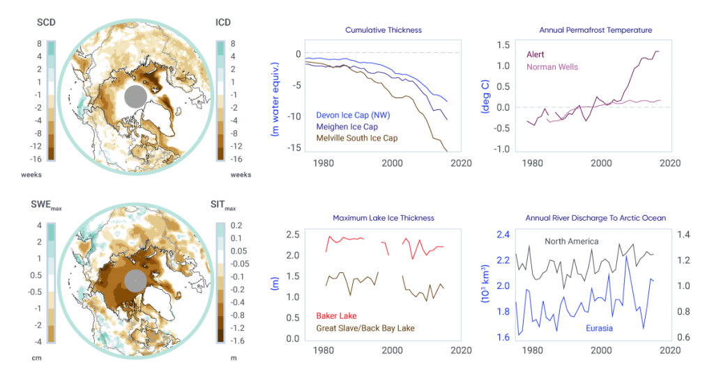
Over the past three decades, the proportion of Canadian land and marine areas covered by snow and ice have decreased, and permafrost temperatures have risen (see Figure 5.1). These changes to the Canadian cryosphere are consistent to those observed in other northern regions (Alaska, northern Europe, and Russia).

Figure-5.1

Indicators of changes in the cryosphere as a result of warming

: Two maps show differences between the periods 2006–2015 and 1981–1990 for the Northern Hemisphere north of 50° north latitude. The first map shows differences in snow and ice cover duration; the second map shows differences in seasonal maximum snow water equivalent and sea ice thickness. The strongest decreases in snow cover duration and maximum snow water equivalent are for eastern Canada, Alaska, northern Europe, and western Siberia. Sea ice cover duration decreased over all Arctic sea ice areas except the interior of the Arctic Ocean. Sea ice thickness decreased over the entire Arctic and all peripheral seas. Four line graphs show time series since 1980 of (1) cumulative ice cap volume change for three locations in the Canadian Arctic Archipelago; (2) permafrost temperature at Norman Wells and Alert; (3) lake ice thickness from measurements on Great Slave Lake and Baker Lake; (4) continentally averaged river discharge to the Arctic Ocean from North America and Eurasia. The line graphs show trends of ice cap volume loss, warming ground temperature, decreasing lake ice thickness, and increasing river discharge.
Figure-5.1

Left: Difference in snow cover duration (SCD) and sea ice cover duration (ICD; upper), and in seasonal maximum snow water equivalent (SWEmax) and sea ice thickness (SITmax; lower) between the periods 2006–2015 and 1981–1990. Right: Time series of cumulative specific volume change (the running total of ice cap surface mass balance divided by ice cap area) for three ice caps in the Canadian Arctic; annual mean ground temperature departure in the sub-Arctic Mackenzie Valley (Norman Wells) and high Arctic (Alert) relative to the 1988–2007 mean; annual maximum lake ice thickness (Great Slave Lake, Northwest Territories and Baker Lake, Nunavut); and annual river discharge summed for rivers draining into the Arctic Ocean from North America and Eurasia.

Source

SCD and SWE from a blend of five snow products; ICD from satellite passive microwave data; and SIT from the PIOMAS Arctic Sea Ice Volume Reanalysis. Ice cap volume data from David Burgess, Natural Resources Canada; ground temperature data from Sharon Smith, Natural Resources Canada; lake ice thickness data from Claude Duguay, University of Waterloo; Arctic river discharge data from Stephen Dery, University of Northern British Columbia.

Snow cover fraction (SCF) decreased across most of Canada during the 1981–2015 period due to delayed snow cover onset in fall and earlier snow melt in spring. Regional and seasonal variability in the SCF trends reflects internal climate variability in surface temperature trends. Over the same time period, seasonal maximum snow water equivalent (SWEmax), which is indicative of seasonally accumulated snow available for spring melt, decreased across the Maritimes, southern Ontario, and nearly all of Canadian land areas north of 55° north latitude, while it increased across southern Saskatchewan and parts of Alberta and British Columbia.

Significant reductions in sea ice area over the period 1968–2016 were evident in the summer and fall across the Canadian Arctic (5% to 20% per decade, depending on region), and in winter and spring in eastern Canadian waters (5% to 10% per decade). Perennial sea ice in the Canadian Arctic is being replaced by thinner seasonal sea ice: multi-year ice losses are greatest in the Beaufort Sea and the Canadian Arctic Archipelago (CAA), approaching 10% per decade. Sixty-year records of landfast sea ice thickness show evidence of thinning ice in the CAA.

Glaciers in Canada have receded over the past century, with a rapid acceleration in area and mass losses over the past decade, due primarily to increasing air temperature. Recent mass loss rates are unprecedented over several millennia. Lake ice cover is changing across Canada, driven primarily by earlier spring breakup. Seasonal ice cover duration declined for approximately 80% of Arctic lakes between 2002 and 2015. Permafrost in the central and southern Mackenzie Valley has warmed at a rate of approximately 0.2°C per decade since the mid-1980s. While modest, these increases are important because permafrost temperatures in these regions are currently close to zero, so the ground is vulnerable to thawing. Permafrost temperatures in the high Arctic have increased at higher rates than in the sub-Arctic, ranging between 0.7°C and 1°C per decade.

These changes to the cryosphere during recent decades are in large part a response to increasing surface temperatures. Regional and seasonal variability are due to natural climate variability in surface temperature trends, changes in the amount and the phase (rain or snow) of precipitation, and to remote influences within the global climate system (such as variations in ocean circulation and sea surface temperatures). Changes to individual components of the cryosphere are interconnected. For example, snow is an effective insulator, so changes in the timing of snow cover onset and the seasonal accumulation of snow strongly influence underlying ground temperature and the thickness of lake and sea ice.

Further changes to the cryosphere over the coming decades are virtually certain, as temperatures are projected to increase under all future emission scenarios. There is robust evidence that snow cover extent and accumulation, sea ice extent and overall thickness, and the mass of land ice will continue to decrease across Canada throughout the 21st century. Most Canadian Arctic marine regions could be sea ice–free for at least one month in the summer by 2050, but sea ice will continue to be found along the northern coast of the CAA. Reductions in glacier mass in western Canada will impact the magnitude and seasonality of streamflow, affecting the availability of freshwater for human use. Warming will lead to a loss of permafrost and alteration of the landscape as thawing occurs. These changes to the cryosphere will not be spatially uniform due to regional effects of natural climate variability at decadal to multi-decadal time scales.

Chapter 6

Changes in Freshwater Availability Across Canada

Key Messages and Summary View Chapter

Chapter 6

Key Messages and Summary

Chapter Key Messages

Surface Runoff: Streamflow

The seasonal timing of peak streamflow has shifted, driven by warming temperatures. Over the last several decades in Canada, spring peak streamflow following snowmelt has occurred earlier, with higher winter and early spring flows (high confidence1). In some areas, reduced summer flows have been observed (medium confidence). These seasonal changes are projected to continue, with corresponding shifts from more snowmelt-dominated regimes toward rainfall-dominated regimes (high confidence). 

There have been no consistent trends in annual streamflow amounts across Canada as a whole. In the future, annual flows are projected to increase in most northern basins but decrease in southern interior continental regions (medium confidence).

Streamflow-related floods result from many factors, and in Canada these mainly include excess precipitation, snowmelt, ice jams, rain-on-snow, or a combination of these factors. There have been no spatially consistent trends in these flood-causing factors or in flooding events across the country as a whole. Projected increases in extreme precipitation are expected to increase the potential for future urban flooding (high confidence). Projected higher temperatures will result in a shift toward earlier floods associated with spring snowmelt, ice jams, and rain-on-snow events (medium confidence). It is uncertain how projected higher temperatures and reductions in snow cover will combine to affect the frequency and magnitude of future snowmelt-related flooding.

Surface Water Levels: Lakes and Wetlands

In regions of Canada where there are sufficient data, there is no indication of long-term changes to lake and wetland levels. Future levels may decline in southern Canada, where increased evaporation may exceed increased precipitation (low confidence). Projected warming and thawing permafrost has the potential to cause future changes, including rapid drainage, in many northern Canadian lakes (medium confidence).

Soil Moisture and Drought

Periodic droughts have occurred across much of Canada, but no long-term changes are evident. Future droughts and soil moisture deficits are projected to be more frequent and intense across the southern Canadian Prairies and interior British Columbia during summer, and to be more prominent at the end of the century under a high emission scenario (medium confidence).

Groundwater

The complexity of groundwater systems and a lack of information make it difficult to assess whether groundwater levels have changed since records began. It is expected that projected changes to temperature and precipitation will influence future groundwater levels; however, the magnitude and even direction of change is not clear. Spring recharge of groundwater aquifers over most of the country is anticipated to occur earlier in the future, as a result of earlier snowmelt (medium confidence).

Freshwater availability in Canada is influenced by a multitude of factors: some natural, some as a result of human activity. Changes in precipitation and temperature have a strong influence, both directly and indirectly, through changes to snow, ice, and permafrost. Disturbances of the water cycle by humans (dams, diversions, and withdrawals) make it difficult to discern climate-related changes. Direct measurements of freshwater availability indicators are inconsistent across the country and, in some cases, too sparse to evaluate past changes. In addition, future changes are determined from a multitude of hydrological models, using output from numerous climate models with different emission scenarios. These factors make it challenging to conduct a pan-Canadian assessment of freshwater availability, and even more difficult to determine whether past changes can be attributed to anthropogenic climate change. In this chapter, national and regional studies are considered, along with information on changes in temperature and precipitation from Chapter 4 and changes to the cryosphere from Chapter 5, to assess changes to freshwater availability in Canada.

Past changes in the seasonality of streamflow have been characterized by earlier spring freshets (the increased flow resulting from snow and ice melt in the spring) due to earlier peaks in spring snowmelt, higher winter and early spring flows, and, for many regions, reduced summer flows. These changes are consistent with observed warming and related changes to snow and ice. During the last 30 to 100 years, annual streamflow magnitudes, surface water levels, soil moisture content and droughts, and shallow groundwater aquifers have, for the most part, been variable, with no clear increasing or decreasing trends. This variability corresponds to observed year-to-year and multi-year variations in precipitation, which are partly influenced by naturally occurring large-scale climate variability (see Chapter 2, Box 2.5). However, for many indicators, there is a lack of evidence (particularly in northern regions of the country) to assess Canada-wide past changes in freshwater availability.

Continued warming and associated reductions in snow cover, shrinking mountain glaciers, and accelerated permafrost thaw are expected to continue to drive changes in the seasonality of streamflow. This includes increased winter flows, even earlier spring freshets, and reduced summer flows, as well as corresponding shifts from more snowmelt-dominated regimes toward rainfall-dominated regimes. Annual streamflow is projected to increase in some areas (mainly northern regions), but decline in others (southern interior regions). Thawing permafrost could cause future changes in many northern Canadian lakes, including rapid drainage. The frequency and intensity of future streamflow-driven flooding are uncertain, because of the complexity of factors involved. Projected increases in extreme precipitation are expected to increase the potential for future urban flooding. However, it is uncertain how projected higher temperatures and reductions in snow cover will combine to affect the frequency and magnitude of future snowmelt-related flooding. Lower surface water levels of lakes and wetlands are expected, especially toward the end of this century, under higher emission scenarios (see Chapter 3, Section 3.2), due to higher temperatures and increased evaporation. However, the magnitude of these decreases will depend on how much future precipitation increases offset increased evaporation.

Future increases in drought and decreases in surface soil moisture are anticipated during summer in the southern Canadian prairies and interior British Columbia, where moisture deficits from increased evapotranspiration are projected to be greater than precipitation increases. These changes are expected to be more prominent toward the end of this century under higher emission scenarios; however, there is considerable uncertainty in their magnitude. Groundwater systems are complex, and, although it is expected that changes to temperature and precipitation will influence future levels, the magnitude and even direction of change is not clear. However, in the future, spring recharge of groundwater aquifers over most of the country is anticipated to occur earlier, as a result of earlier snowmelt.

These anticipated changes from anthropogenic climate warming will directly affect the timing and amount of future freshwater supplies, and they may be exacerbated by human management alterations to freshwater systems. The impacts are expected to be more prominent toward the end of this century under higher emission scenarios, given the larger associated climate changes. Of particular concern are impacts in regions that currently rely on snow and ice melt as freshwater sources, as well as continental interior areas, where increased evapotranspiration from warmer temperatures could reduce future water supplies. However, freshwater supplies in all regions of Canada are expected to be affected in one way or another. It is also anticipated that water-related extremes, such as droughts and floods, will intensify these impacts.
Chapter 7

Key Messages and Summary

Chapter Key Messages

Ocean Temperature

Upper-ocean temperature has increased in the Northeast Pacific and most areas of the Northwest Atlantic over the last century, consistent with anthropogenic climate change (high confidence). The upper ocean has warmed in the Canadian Arctic in summer and fall as a result of increases in air temperature and declines in sea ice (medium confidence).

Oceans surrounding Canada are projected to continue to warm over the 21st century in response to past and future emissions of greenhouse gases. The warming in summer will be greatest in the ice-free areas of the Arctic and off southern Atlantic Canada, where subtropical water is projected to shift further north (medium confidence). During winter in the next few decades, the upper ocean surrounding Atlantic Canada will warm the most, the Northeast Pacific will experience intermediate warming rates, and the Arctic and eastern sub-Arctic ocean areas (including Hudson Bay and Labrador Sea) will warm the least (medium confidence).

Ocean Salinity and Density Stratification

There has been a slight long-term freshening of upper-ocean waters in most areas off Canada as a result of various factors related to anthropogenic climate change, in addition to natural decadal-scale variability (medium confidence). Salinity has increased below the surface in some mid-latitude areas, indicating a northward shift of saltier subtropical water (medium confidence).

Freshening of the ocean surface is projected to continue in most areas off Canada over the rest of this century under a range of emission scenarios, due to increases in precipitation and melting of land and sea ice (medium confidence). However, increases in salinity are expected in off-shelf waters south of Atlantic Canada due to the northward shift of subtropical water (medium confidence). The upper-ocean freshening and warming is expected to increase the vertical stratification of water density, which will affect ocean sequestration of greenhouse gases, dissolved oxygen levels, and marine ecosystems.

Marine Winds, Storms, and Waves

Surface wave heights and the duration of the wave season in the Canadian Arctic have increased since 1970 and are projected to continue to increase over this century as sea ice declines (high confidence). Off Canada’s east coast, areas that currently have seasonal sea ice are also anticipated to experience increased wave activity in the future, as seasonal ice duration decreases (medium confidence).

A slight northward shift of storm tracks, with decreased wind speed and lower wave heights off Atlantic Canada, has been observed and is projected to continue in future (low confidence). Off the Pacific coast of Canada, wave heights have been observed to increase in winter and decrease in summer, and these trends are projected to continue in future (low confidence).

Sea Level

Globally, sea level has risen, and is projected to continue to rise. The projected amount of global sea-level rise in the 21st century is many tens of centimetres and it may exceed one metre. However, relative sea level in different parts of Canada is projected to rise or fall, depending on local vertical land motion. Due to land subsidence, parts of Atlantic Canada are projected to experience relative sea-level change higher than the global average during the coming century (high confidence).

 Where relative sea level is projected to rise (most of the Atlantic and Pacific coasts and the Beaufort coast in the Arctic), the frequency and magnitude of extreme high water-level events will increase (high confidence). This will result in increased flooding, which is expected to lead to infrastructure and ecosystem damage as well as coastline erosion, putting communities at risk. Adaptation actions need to be tailored to local projections of relative sea-level change.

Extreme high water-level events are expected to become larger and occur more often in areas where, and in seasons when, there is increased open water along Canada’s Arctic and Atlantic coasts, as a result of declining sea ice cover, leading to increased wave action and larger storm surges (high confidence).

Ocean Chemistry

Increasing acidity (decreasing pH) of the upper-ocean waters surrounding Canada has been observed, consistent with increased carbon dioxide uptake from the atmosphere (high confidence). This trend is expected to continue, with acidification occurring most rapidly in the Arctic Ocean (high confidence).

Subsurface oxygen concentrations have decreased in the Northeast Pacific and Northwest Atlantic oceans off Canada (high confidence). Increased upper-ocean temperature and density stratification associated with anthropogenic climate change have contributed to this decrease (medium confidence). Low subsurface oxygen conditions will become more widespread and detrimental to marine life in future, as a result of continuing climate change (medium confidence).

Nutrient supply to the ocean-surface layer has generally decreased in the North Pacific Ocean, consistent with increasing upper-ocean stratification (medium confidence). No consistent pattern of nutrient change has been observed for the Northwest Atlantic Ocean off Canada. There are no long-term nutrient data available for the Canadian Arctic.


The global ocean covers approximately 71% of the Earth’s surface and is a vast reservoir of water, energy, carbon, and many other substances. It is a key component of the climate system and interacts directly with the atmosphere and cryosphere. Freshwater resources are also linked to the ocean via runoff in coastal areas. The ocean plays an important role in mitigating anthropogenic climate change through its ability to absorb substantial amounts of heat and carbon.

Canada is surrounded by oceans on three sides — the Pacific, Arctic, and Atlantic oceans. There is strong evidence of human-induced changes during the past century in key ocean-climate properties — such as temperature, sea ice, sea level, acidity, and dissolved oxygen — off Canada. Warmer ocean temperature has contributed to declining sea ice and increasing sea level. However, there is an area south of Greenland where there has been little ocean warming, so regional trends do differ. Warming and a slight freshening of the upper ocean have reduced its density resulting in increased vertical differences in density (referred to as “density stratification”) in oceans off Canada; this could affect the vertical transport of heat, carbon, and nutrients and, thereby, ecosystem health and services.

Global sea levels are rising due to ocean thermal expansion, and diminishing glaciers and ice sheets which deliver water to the oceans. Changes in sea level relative to Canada’s coastline are also affected by vertical land motion (upward, called “uplift” or downward, called “subsidence”) in response to the retreat of the last glacial ice sheet. Relative sea level has increased in most regions of Canada over the last century and even exceeded the global rate of change in southern Atlantic Canada, where land is subsiding. However, there are regions of Canada (e.g., Hudson Bay) where relative sea level has fallen as a result of the rate of uplift being higher than the rate of global sea-level rise. Increasing relative sea level is also increasing risks for coastal infrastructure and communities. This is compounded by increases in ocean wave heights in areas that have experienced seasonal reductions in sea ice.

Ocean chemistry has undergone changes, such as increasing acidity and decreasing subsurface oxygen concentrations, as a result of anthropogenic climate change. The physical and chemical trends observed in the oceans surrounding Canada are consistent with changes observed in the atmosphere, cryosphere, freshwater systems, and adjoining oceans.

The fundamental principles that govern how the physical and chemical environment of the ocean will respond to increased atmospheric carbon dioxide have allowed model-based projections of future conditions in the oceans surrounding Canada under a range of emission scenarios. In general, warming and freshening at the ocean surface is projected during this century, which will continue to increase stratification and reduce sea ice. Sea-level rise along some Canadian coastlines will be higher than the global average during this century, leading to increased flooding and erosion. Ocean acidification and decreasing subsurface oxygen levels will continue, with increasingly adverse implications for marine ecosystems.

Chapter 8

Changes in Canada's Regions in a National and Global Context

View Chapter